

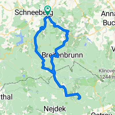
Brünlasberg Trail
A cycling route starting in Aue, Saxony, Germany.
Overview
About this route
Short but intense trail.
Starts with a steep climb, followed by a flowing midsection, and ends with a rocky downhill.
Those looking to push themselves hard over a short distance will find this trail rewarding.
- -:--
- Duration
- 5.4 km
- Distance
- 234 m
- Ascent
- 236 m
- Descent
- ---
- Avg. speed
- ---
- Max. altitude

Continue with Bikemap
Use, edit, or download this cycling route
You would like to ride Brünlasberg Trail or customize it for your own trip? Here is what you can do with this Bikemap route:
Free features
- Save this route as favorite or in collections
- Copy & plan your own version of this route
- Sync your route with Garmin or Wahoo
Premium features
Free trial for 3 days, or one-time payment. More about Bikemap Premium.
- Navigate this route on iOS & Android
- Export a GPX / KML file of this route
- Create your custom printout (try it for free)
- Download this route for offline navigation
Discover more Premium features.
Get Bikemap PremiumFrom our community
Other popular routes starting in Aue
 Aue - Auersberg - Aue
- Distance
- 45.6 km
- Ascent
- 701 m
- Descent
- 701 m
- Location
- Aue, Saxony, Germany
 Floßgraben-Rechenhaus-Wasserfall-Weitersglashütte-Sauschwemme-Sosa-Rechenhaus-zurück bis Start
- Distance
- 58.5 km
- Ascent
- 727 m
- Descent
- 730 m
- Location
- Aue, Saxony, Germany
 Aue - Sosaer Talsperre
- Distance
- 38.9 km
- Ascent
- 553 m
- Descent
- 550 m
- Location
- Aue, Saxony, Germany
 Aue - Sosa - Steinbach - Pernink - Plesivec - Pernink - Schwarzenberg - Aue
- Distance
- 85.8 km
- Ascent
- 1,066 m
- Descent
- 1,066 m
- Location
- Aue, Saxony, Germany
 Floßgraben Neudörfel - Bockau - Neudörfel
- Distance
- 13.8 km
- Ascent
- 261 m
- Descent
- 261 m
- Location
- Aue, Saxony, Germany
 Aue-Fichtelberg-Meluzina
- Distance
- 147.2 km
- Ascent
- 3,121 m
- Descent
- 3,123 m
- Location
- Aue, Saxony, Germany
 Germany Tour 2.0 Stage 7 (Aue - Weimar)
- Distance
- 148 km
- Ascent
- 687 m
- Descent
- 822 m
- Location
- Aue, Saxony, Germany
 Firmenlauf Erzgebirge
- Distance
- 5 km
- Ascent
- 55 m
- Descent
- 56 m
- Location
- Aue, Saxony, Germany
Open it in the app