

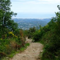
gorges du cian
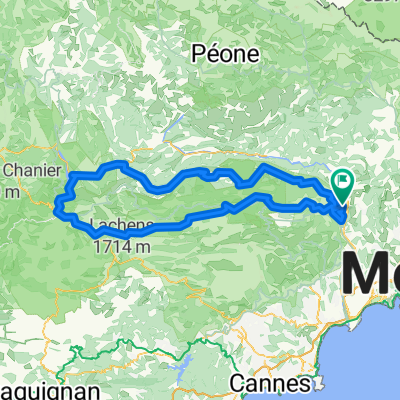
A cycling route starting in Gilette, Provence-Alpes-Côte d'Azur Region, France.
Overview
About this route
- -:--
- Duration
- 78.7 km
- Distance
- 1,213 m
- Ascent
- 1,184 m
- Descent
- ---
- Avg. speed
- ---
- Max. altitude
Route quality
Waytypes & surfaces along the route
Waytypes
Busy road
47.4 km
(60 %)
Road
24.8 km
(31 %)
Surfaces
Paved
38.8 km
(49 %)
Unpaved
1.3 km
(2 %)
Asphalt
38.8 km
(49 %)
Gravel
1.3 km
(2 %)
Undefined
38.7 km
(49 %)
Continue with Bikemap
Use, edit, or download this cycling route
You would like to ride gorges du cian or customize it for your own trip? Here is what you can do with this Bikemap route:
Free features
- Save this route as favorite or in collections
- Copy & plan your own version of this route
- Sync your route with Garmin or Wahoo
Premium features
Free trial for 3 days, or one-time payment. More about Bikemap Premium.
- Navigate this route on iOS & Android
- Export a GPX / KML file of this route
- Create your custom printout (try it for free)
- Download this route for offline navigation
Discover more Premium features.
Get Bikemap PremiumFrom our community
Other popular routes starting in Gilette
 Roquesteron - Nizza
- Distance
- 77.1 km
- Ascent
- 1,734 m
- Descent
- 2,024 m
- Location
- Gilette, Provence-Alpes-Côte d'Azur Region, France
 Autour de Gilette
- Distance
- 39.4 km
- Ascent
- 899 m
- Descent
- 899 m
- Location
- Gilette, Provence-Alpes-Côte d'Azur Region, France
 Itinéraire vers 931 Route du Cougnet, Briançonnet
- Distance
- 45.2 km
- Ascent
- 1,056 m
- Descent
- 395 m
- Location
- Gilette, Provence-Alpes-Côte d'Azur Region, France
 Tourette-Col St Raphael
- Distance
- 70.8 km
- Ascent
- 1,036 m
- Descent
- 1,036 m
- Location
- Gilette, Provence-Alpes-Côte d'Azur Region, France
 5573–5585 Route de Roquesteron, Gilette à 931 Route du Cougnet, Briançonnet
- Distance
- 45.2 km
- Ascent
- 1,090 m
- Descent
- 432 m
- Location
- Gilette, Provence-Alpes-Côte d'Azur Region, France
 Tournee Esteron
- Distance
- 181.8 km
- Ascent
- 2,494 m
- Descent
- 2,507 m
- Location
- Gilette, Provence-Alpes-Côte d'Azur Region, France
 Paris Nice 22-roquestron-cagnes
- Distance
- 71.4 km
- Ascent
- 1,189 m
- Descent
- 1,512 m
- Location
- Gilette, Provence-Alpes-Côte d'Azur Region, France
 Tour Estéron (raccourci Vescous)
- Distance
- 56.4 km
- Ascent
- 1,460 m
- Descent
- 1,464 m
- Location
- Gilette, Provence-Alpes-Côte d'Azur Region, France
Open it in the app