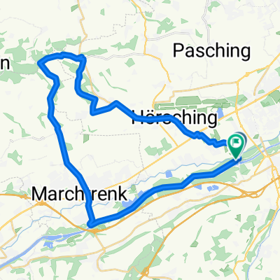
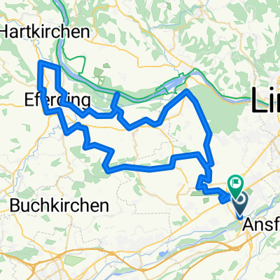
Traun-Ansfelden-Marchtrenk-Traun
A cycling route starting in Traun, Upper Austria, Austria.
Overview
About this route
- -:--
- Duration
- 41.8 km
- Distance
- 304 m
- Ascent
- 297 m
- Descent
- ---
- Avg. speed
- 359 m
- Avg. speed
Route quality
Waytypes & surfaces along the route
Waytypes
Quiet road
19.5 km
(47 %)
Road
5.5 km
(13 %)
Surfaces
Paved
21.1 km
(51 %)
Unpaved
0.3 km
(<1 %)
Asphalt
20.9 km
(50 %)
Gravel
0.3 km
(<1 %)
Continue with Bikemap
Use, edit, or download this cycling route
You would like to ride Traun-Ansfelden-Marchtrenk-Traun or customize it for your own trip? Here is what you can do with this Bikemap route:
Free features
- Save this route as favorite or in collections
- Copy & plan your own version of this route
- Sync your route with Garmin or Wahoo
Premium features
Free trial for 3 days, or one-time payment. More about Bikemap Premium.
- Navigate this route on iOS & Android
- Export a GPX / KML file of this route
- Create your custom printout (try it for free)
- Download this route for offline navigation
Discover more Premium features.
Get Bikemap PremiumFrom our community
Other popular routes starting in Traun
- Stifterstraße 2, Traun nach Leondinger Straße 39, Traun
- Distance
- 10.3 km
- Ascent
- 100 m
- Descent
- 97 m
- Location
- Traun, Upper Austria, Austria
- Lessingstraße 3, Traun nach Lessingstraße 1, Traun
- Distance
- 7.5 km
- Ascent
- 36 m
- Descent
- 51 m
- Location
- Traun, Upper Austria, Austria
- Traun-Ansfelden-Marchtrenk-Traun
- Distance
- 41.8 km
- Ascent
- 304 m
- Descent
- 297 m
- Location
- Traun, Upper Austria, Austria
- Traun-Gmunden R4
- Distance
- 57.8 km
- Ascent
- 284 m
- Descent
- 128 m
- Location
- Traun, Upper Austria, Austria
- Fähre Mauthausen
- Distance
- 53.9 km
- Ascent
- 384 m
- Descent
- 383 m
- Location
- Traun, Upper Austria, Austria
- mit damili
- Distance
- 10.4 km
- Ascent
- 280 m
- Descent
- 288 m
- Location
- Traun, Upper Austria, Austria
- Donau-Runde
- Distance
- 41.8 km
- Ascent
- 52 m
- Descent
- 52 m
- Location
- Traun, Upper Austria, Austria
- Schloßstraße 48a, Traun nach Doblerholz, Leonding
- Distance
- 6 km
- Ascent
- 55 m
- Descent
- 18 m
- Location
- Traun, Upper Austria, Austria
Open it in the app