

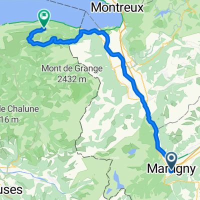
Belle montée, peu de voitures
A cycling route starting in Martigny-Ville, Valais, Switzerland.
Overview
About this route
Near Martigny, the view is beautiful, the slope is steep, the tarmac is excellent. Little traffic. Warm at noon. Ideal for a short and intensive training session... or a nice short and relaxed ride. It is worth stopping to admire... whether going downhill or uphill... depending on the moment!
- -:--
- Duration
- 20.4 km
- Distance
- 975 m
- Ascent
- 38 m
- Descent
- ---
- Avg. speed
- ---
- Max. altitude

Route quality
Waytypes & surfaces along the route
Waytypes
Quiet road
16.1 km
(79 %)
Road
2.2 km
(11 %)
Surfaces
Paved
3.9 km
(19 %)
Asphalt
3.9 km
(19 %)
Undefined
16.5 km
(81 %)
Continue with Bikemap
Use, edit, or download this cycling route
You would like to ride Belle montée, peu de voitures or customize it for your own trip? Here is what you can do with this Bikemap route:
Free features
- Save this route as favorite or in collections
- Copy & plan your own version of this route
- Sync your route with Garmin or Wahoo
Premium features
Free trial for 3 days, or one-time payment. More about Bikemap Premium.
- Navigate this route on iOS & Android
- Export a GPX / KML file of this route
- Create your custom printout (try it for free)
- Download this route for offline navigation
Discover more Premium features.
Get Bikemap PremiumFrom our community
Other popular routes starting in Martigny-Ville
 MartignyDay1TwoBlackTwoBlueSingletracks
- Distance
- 20.2 km
- Ascent
- 909 m
- Descent
- 908 m
- Location
- Martigny-Ville, Valais, Switzerland
 Etape 4 : Martigny - Station de Verbier (Tour de Suisse, Aramis) 40 km
- Distance
- 40.5 km
- Ascent
- 2,293 m
- Descent
- 653 m
- Location
- Martigny-Ville, Valais, Switzerland
 1. Etappe: Martigny - Rund um den Mont Blanc nach Les Saisies
- Distance
- 100 km
- Ascent
- 2,702 m
- Descent
- 1,515 m
- Location
- Martigny-Ville, Valais, Switzerland
![[Martigny_000] Col de la Croix de Cœur.](https://media.bikemap.net/routes/7804754/staticmaps/in_04321c4c-7a5d-49a7-82fe-ade858784fb8_400x400_bikemap-2021-3D-static.png) [Martigny_000] Col de la Croix de Cœur.
[Martigny_000] Col de la Croix de Cœur.- Distance
- 69.2 km
- Ascent
- 1,699 m
- Descent
- 1,698 m
- Location
- Martigny-Ville, Valais, Switzerland
 Martigny - Col du Sanetsch
- Distance
- 55.5 km
- Ascent
- 1,768 m
- Descent
- 193 m
- Location
- Martigny-Ville, Valais, Switzerland
 VR04 Martigny-St Gingolph.kml - VR04 Martigny-St Gingolph.kml_VR04 Martigny-St Gingolph
- Distance
- 60.4 km
- Ascent
- 408 m
- Descent
- 484 m
- Location
- Martigny-Ville, Valais, Switzerland
 Martigny-Thollon
- Distance
- 69.9 km
- Ascent
- 1,891 m
- Descent
- 1,444 m
- Location
- Martigny-Ville, Valais, Switzerland
 BRUTAL 2017
- Distance
- 1,011.3 km
- Ascent
- 10,738 m
- Descent
- 11,175 m
- Location
- Martigny-Ville, Valais, Switzerland
Open it in the app