

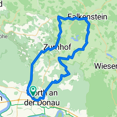
2012 Wörth/Donau-Regensburg-Meihern/Altmühl
A cycling route starting in Wörth an der Donau, Bavaria, Germany.
Overview
About this route
Known route, the south side of the Danube cycle path to Regensburg is better with more shade and shorter to Kelheim.
Kelheim: NO signs on the cycle path to Weltenburg or ferry or something, IDIOTS!
So through via Riedenburg.
The weather looks stormy, so continuing to the campsite Mehren under the info house roof.
The hottest day of the year!
- -:--
- Duration
- 97.5 km
- Distance
- 107 m
- Ascent
- 73 m
- Descent
- ---
- Avg. speed
- ---
- Max. altitude
Route quality
Waytypes & surfaces along the route
Waytypes
Track
34.1 km
(35 %)
Path
21.5 km
(22 %)
Surfaces
Paved
50.7 km
(52 %)
Unpaved
39 km
(40 %)
Asphalt
50.7 km
(52 %)
Gravel
22.4 km
(23 %)
Route highlights
Points of interest along the route
Point of interest after 33.3 km
gute Konditorei,schönes haus klasse kaffee,super suppen
Point of interest after 37 km
Bad in der Donau
Point of interest after 55.3 km
Hängematten Mittags Pause
Point of interest after 84.9 km
Hängemattenpause bei 36 grad,baden in der Altmühl
Point of interest after 87.6 km
Eisdiele
Point of interest after 97.5 km
Ü Platz Infopoint,sehr gut weil Unwetter,völlig trocken!
Continue with Bikemap
Use, edit, or download this cycling route
You would like to ride 2012 Wörth/Donau-Regensburg-Meihern/Altmühl or customize it for your own trip? Here is what you can do with this Bikemap route:
Free features
- Save this route as favorite or in collections
- Copy & plan your own version of this route
- Split it into stages to create a multi-day tour
- Sync your route with Garmin or Wahoo
Premium features
Free trial for 3 days, or one-time payment. More about Bikemap Premium.
- Navigate this route on iOS & Android
- Export a GPX / KML file of this route
- Create your custom printout (try it for free)
- Download this route for offline navigation
Discover more Premium features.
Get Bikemap PremiumFrom our community
Other popular routes starting in Wörth an der Donau
 Wellerbach - Perlbach über Aumbach
- Distance
- 21.9 km
- Ascent
- 390 m
- Descent
- 391 m
- Location
- Wörth an der Donau, Bavaria, Germany
 2010 Wörth/Donau-Plattling
- Distance
- 57.8 km
- Ascent
- 82 m
- Descent
- 81 m
- Location
- Wörth an der Donau, Bavaria, Germany
 2012 Wörth/Donau-Regensburg-Meihern/Altmühl
- Distance
- 97.5 km
- Ascent
- 107 m
- Descent
- 73 m
- Location
- Wörth an der Donau, Bavaria, Germany
 D11 Wörth - Deggendorf
- Distance
- 67.9 km
- Ascent
- 81 m
- Descent
- 95 m
- Location
- Wörth an der Donau, Bavaria, Germany
 Brennberg Sulzbach 01
- Distance
- 39.2 km
- Ascent
- 492 m
- Descent
- 507 m
- Location
- Wörth an der Donau, Bavaria, Germany
 Donauauen auf Damm
- Distance
- 26.8 km
- Ascent
- 65 m
- Descent
- 53 m
- Location
- Wörth an der Donau, Bavaria, Germany
 Gfäll - Falkenstein
- Distance
- 37.9 km
- Ascent
- 517 m
- Descent
- 510 m
- Location
- Wörth an der Donau, Bavaria, Germany
 Thiergarten - Donau - Runde
- Distance
- 34.4 km
- Ascent
- 492 m
- Descent
- 490 m
- Location
- Wörth an der Donau, Bavaria, Germany
Open it in the app