

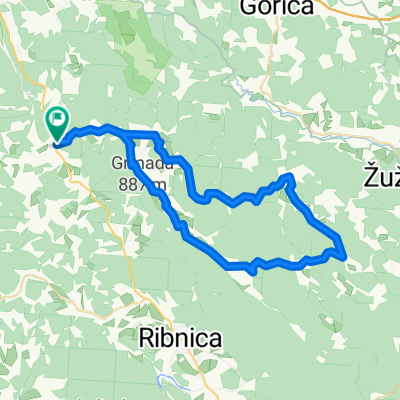
zapotok-slivnica
A cycling route starting in Velike Lašče, Občina Velike Lašče, Slovenia.
Overview
About this route
- -:--
- Duration
- 34.9 km
- Distance
- 945 m
- Ascent
- 475 m
- Descent
- ---
- Avg. speed
- ---
- Max. altitude

Route quality
Waytypes & surfaces along the route
Waytypes
Road
23.4 km
(67 %)
Quiet road
8 km
(23 %)
Track
3.5 km
(10 %)
Surfaces
Paved
25.8 km
(74 %)
Unpaved
7 km
(20 %)
Asphalt
24.4 km
(70 %)
Gravel
7 km
(20 %)
Route highlights
Points of interest along the route
Point of interest after 3 km
Lipa stara več kot 100 let
Point of interest after 3 km
Continue with Bikemap
Use, edit, or download this cycling route
You would like to ride zapotok-slivnica or customize it for your own trip? Here is what you can do with this Bikemap route:
Free features
- Save this route as favorite or in collections
- Copy & plan your own version of this route
- Sync your route with Garmin or Wahoo
Premium features
Free trial for 3 days, or one-time payment. More about Bikemap Premium.
- Navigate this route on iOS & Android
- Export a GPX / KML file of this route
- Create your custom printout (try it for free)
- Download this route for offline navigation
Discover more Premium features.
Get Bikemap PremiumFrom our community
Other popular routes starting in Velike Lašče
 kLANCI
- Distance
- 63.3 km
- Ascent
- 710 m
- Descent
- 713 m
- Location
- Velike Lašče, Občina Velike Lašče, Slovenia
 45 - suha krajina
- Distance
- 54.9 km
- Ascent
- 607 m
- Descent
- 607 m
- Location
- Velike Lašče, Občina Velike Lašče, Slovenia
 Recording from 21. junij 12:27
- Distance
- 28.2 km
- Ascent
- 848 m
- Descent
- 605 m
- Location
- Velike Lašče, Občina Velike Lašče, Slovenia
 AŠČE,ZDENv.LSKA VAS,LJ,POD TURJAK,V.LAŠČE
- Distance
- 61 km
- Ascent
- 411 m
- Descent
- 410 m
- Location
- Velike Lašče, Občina Velike Lašče, Slovenia
 HRIBOVITO
- Distance
- 33.6 km
- Ascent
- 684 m
- Descent
- 683 m
- Location
- Velike Lašče, Občina Velike Lašče, Slovenia
 ;ačji rep
- Distance
- 3.5 km
- Ascent
- 442 m
- Descent
- 191 m
- Location
- Velike Lašče, Občina Velike Lašče, Slovenia
 From Trubar to Cankar and back CLASSIC
- Distance
- 112.3 km
- Ascent
- 734 m
- Descent
- 734 m
- Location
- Velike Lašče, Občina Velike Lašče, Slovenia
 Rob - Rob 29km circle
- Distance
- 29 km
- Ascent
- 1,083 m
- Descent
- 1,153 m
- Location
- Velike Lašče, Občina Velike Lašče, Slovenia
Open it in the app