

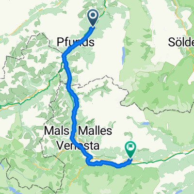
Csbike+A+G Bike Serfaus Schonjoch Fiss 08/2012
A cycling route starting in Serfaus, Tyrol, Austria.
Overview
About this route
a
- -:--
- Duration
- 32.3 km
- Distance
- 1,349 m
- Ascent
- 1,358 m
- Descent
- ---
- Avg. speed
- ---
- Max. altitude

Continue with Bikemap
Use, edit, or download this cycling route
You would like to ride Csbike+A+G Bike Serfaus Schonjoch Fiss 08/2012 or customize it for your own trip? Here is what you can do with this Bikemap route:
Free features
- Save this route as favorite or in collections
- Copy & plan your own version of this route
- Sync your route with Garmin or Wahoo
Premium features
Free trial for 3 days, or one-time payment. More about Bikemap Premium.
- Navigate this route on iOS & Android
- Export a GPX / KML file of this route
- Create your custom printout (try it for free)
- Download this route for offline navigation
Discover more Premium features.
Get Bikemap PremiumFrom our community
Other popular routes starting in Serfaus
 Tösens - Blautal - Pfunds - Tösens
- Distance
- 17.4 km
- Ascent
- 536 m
- Descent
- 536 m
- Location
- Serfaus, Tyrol, Austria
 Csbike+A+G Bike Serfaus Schonjoch Fiss 08/2012
- Distance
- 32.3 km
- Ascent
- 1,349 m
- Descent
- 1,358 m
- Location
- Serfaus, Tyrol, Austria
 Langsame Fahrt in Serfaus
- Distance
- 23.1 km
- Ascent
- 1,513 m
- Descent
- 1,506 m
- Location
- Serfaus, Tyrol, Austria
 Serfaus Lazid
- Distance
- 8.9 km
- Ascent
- 943 m
- Descent
- 43 m
- Location
- Serfaus, Tyrol, Austria
 Von Serfaus bis Mals
- Distance
- 72.8 km
- Ascent
- 2,113 m
- Descent
- 2,487 m
- Location
- Serfaus, Tyrol, Austria
 Obertösens 133, Tösens nach Obertösens 133, Tösens
- Distance
- 24.8 km
- Ascent
- 2,333 m
- Descent
- 2,333 m
- Location
- Serfaus, Tyrol, Austria
 Komperdell Serfaus
- Distance
- 4.4 km
- Ascent
- 39 m
- Descent
- 573 m
- Location
- Serfaus, Tyrol, Austria
 Serfaus - Nauders
- Distance
- 77.9 km
- Ascent
- 2,009 m
- Descent
- 2,274 m
- Location
- Serfaus, Tyrol, Austria
Open it in the app