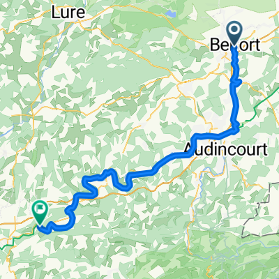
TourdeF2012_E02
A cycling route starting in Belfort, Bourgogne-Franche-Comté, France.
Overview
About this route
BELFORT - MORTEAU
via Montbeliard - Point-de-Rode - St. Hippolyte - Goumois - Damprichard - Fourmet-Blancheroche - Le Russey
- -:--
- Duration
- 117.6 km
- Distance
- 1,211 m
- Ascent
- 812 m
- Descent
- ---
- Avg. speed
- ---
- Max. altitude
Route quality
Waytypes & surfaces along the route
Waytypes
Busy road
95.5 km
(81 %)
Quiet road
11.5 km
(10 %)
Surfaces
Paved
69.2 km
(59 %)
Unpaved
0.1 km
(<1 %)
Asphalt
63.7 km
(54 %)
Paved (undefined)
5.4 km
(5 %)
Route highlights
Points of interest along the route
Point of interest after 0.6 km
BELFORT
Point of interest after 17.3 km
Montbeliard
Point of interest after 33.4 km
Point-de-Rode
Point of interest after 44.3 km
Saint Hippolyte
Point of interest after 117.2 km
MORTEAU
Continue with Bikemap
Use, edit, or download this cycling route
You would like to ride TourdeF2012_E02 or customize it for your own trip? Here is what you can do with this Bikemap route:
Free features
- Save this route as favorite or in collections
- Copy & plan your own version of this route
- Split it into stages to create a multi-day tour
- Sync your route with Garmin or Wahoo
Premium features
Free trial for 3 days, or one-time payment. More about Bikemap Premium.
- Navigate this route on iOS & Android
- Export a GPX / KML file of this route
- Create your custom printout (try it for free)
- Download this route for offline navigation
Discover more Premium features.
Get Bikemap PremiumFrom our community
Other popular routes starting in Belfort
- Belfort - Colmar
- Distance
- 244 km
- Ascent
- 4,341 m
- Descent
- 4,500 m
- Location
- Belfort, Bourgogne-Franche-Comté, France
- Centre Belfort » Lac Malsaucy
- Distance
- 17.5 km
- Ascent
- 56 m
- Descent
- 56 m
- Location
- Belfort, Bourgogne-Franche-Comté, France
- CSA CYCLO 97 KM Col Hundruck
- Distance
- 96.4 km
- Ascent
- 674 m
- Descent
- 673 m
- Location
- Belfort, Bourgogne-Franche-Comté, France
- *16-M. Belfort - Colmar (164,5 Km)
- Distance
- 164.5 km
- Ascent
- 3,289 m
- Descent
- 3,459 m
- Location
- Belfort, Bourgogne-Franche-Comté, France
- Autour de Belfort - Canal de la Haute Saône
- Distance
- 16.3 km
- Ascent
- 75 m
- Descent
- 73 m
- Location
- Belfort, Bourgogne-Franche-Comté, France
- Belfort - Saint-Dié-des-Vosges
- Distance
- 175.1 km
- Ascent
- 3,131 m
- Descent
- 3,150 m
- Location
- Belfort, Bourgogne-Franche-Comté, France
- CYCLO CSA 106 KM 3 clos
- Distance
- 106.1 km
- Ascent
- 1,436 m
- Descent
- 1,436 m
- Location
- Belfort, Bourgogne-Franche-Comté, France
- Alpen/Provence 2018 - 9. Tag
- Distance
- 158.1 km
- Ascent
- 905 m
- Descent
- 925 m
- Location
- Belfort, Bourgogne-Franche-Comté, France
Open it in the app