
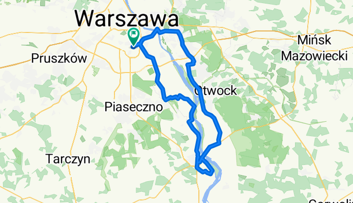
Mokotów - Gassy - Czersk - Góra Kalwaria - Falenica - Mokotów
A cycling route starting in Mokotów, Masovian Voivodeship, Poland.
Overview
About this route
Malownicza dolina Wisły w Gassach, zamek w Czersku oraz sporo ścieżek rowerowych po drugiej stronie Wisły.
Wymagająca pętla, raczej dla roweru górskiego (Gassy - tam przejeżdża się wąskim wałem wzdłuż Wisły, a ścieżka rowerowa z Góry Kalwarii do Czerska idzie ostro w dół po kocich łbach).
Droga krajowa nr 50 z Góry Kalwarii - lepiej jak najszybciej mieć ją za sobą (duże nasilenie ruchu, mnóstwo tirów).
Z pewnymi modyfikacjami trasa nadaje się dla roweru szosowego.
- -:--
- Duration
- 90 km
- Distance
- 113 m
- Ascent
- 113 m
- Descent
- ---
- Avg. speed
- ---
- Max. altitude
Route quality
Waytypes & surfaces along the route
Waytypes
Road
28 km
(31 %)
Busy road
23.7 km
(26 %)
Surfaces
Paved
67.5 km
(75 %)
Unpaved
5.9 km
(7 %)
Asphalt
65.7 km
(73 %)
Unpaved (undefined)
3.3 km
(4 %)
Continue with Bikemap
Use, edit, or download this cycling route
You would like to ride Mokotów - Gassy - Czersk - Góra Kalwaria - Falenica - Mokotów or customize it for your own trip? Here is what you can do with this Bikemap route:
Free features
- Save this route as favorite or in collections
- Copy & plan your own version of this route
- Split it into stages to create a multi-day tour
- Sync your route with Garmin or Wahoo
Premium features
Free trial for 3 days, or one-time payment. More about Bikemap Premium.
- Navigate this route on iOS & Android
- Export a GPX / KML file of this route
- Create your custom printout (try it for free)
- Download this route for offline navigation
Discover more Premium features.
Get Bikemap PremiumFrom our community
Other popular routes starting in Mokotów
 Las Bielanski – Kampinos – Łosiowe Błota – Miasto Ogród Włochy
- Distance
- 53.4 km
- Ascent
- 59 m
- Descent
- 57 m
- Location
- Mokotów, Masovian Voivodeship, Poland
 Niedziela z Kolarskim - 115 km
- Distance
- 115.5 km
- Ascent
- 139 m
- Descent
- 137 m
- Location
- Mokotów, Masovian Voivodeship, Poland
 Antoniego Edwarda Odyńca 71, Warszawa do Antoniego Edwarda Odyńca 71, Warszawa
- Distance
- 66.9 km
- Ascent
- 322 m
- Descent
- 322 m
- Location
- Mokotów, Masovian Voivodeship, Poland
 Terenowa pętla
- Distance
- 55.4 km
- Ascent
- 80 m
- Descent
- 85 m
- Location
- Mokotów, Masovian Voivodeship, Poland
 pierwsza100#2
- Distance
- 102.8 km
- Ascent
- 133 m
- Descent
- 130 m
- Location
- Mokotów, Masovian Voivodeship, Poland
 Świdermajer
- Distance
- 62.7 km
- Ascent
- 51 m
- Descent
- 50 m
- Location
- Mokotów, Masovian Voivodeship, Poland
 Las Kabacki – Piaseczno – Chojnów – Zalesie Górne – Rezerwat przyrody Łoś – Lasy Sękocińskie
- Distance
- 86.9 km
- Ascent
- 151 m
- Descent
- 152 m
- Location
- Mokotów, Masovian Voivodeship, Poland
 Służewiec - Wilanów - Okrzeszyn - Powsin - Kabaty - Służewiec.
- Distance
- 35.8 km
- Ascent
- 69 m
- Descent
- 69 m
- Location
- Mokotów, Masovian Voivodeship, Poland
Open it in the app