

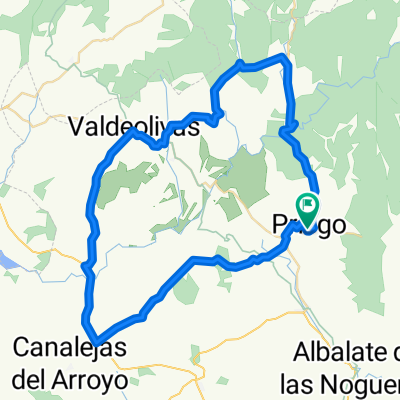
Ruta Priego - Alcantud - El Pozuelo - Peñalén - Beteta - Priego
A cycling route starting in Priego, Castille-La Mancha, Spain.
Overview
About this route
Proposed route for September 9, 2012. Route passes through: Priego, Alcantud, El Pozuelo, Villanueva de Alcorón, Peñalén, Beteta, Vadillos, Cañizares, Cañamares and Priego.
- -:--
- Duration
- 97.1 km
- Distance
- 2,678 m
- Ascent
- 2,681 m
- Descent
- ---
- Avg. speed
- ---
- Max. altitude

Route quality
Waytypes & surfaces along the route
Waytypes
Road
19.4 km
(20 %)
Track
5.8 km
(6 %)
Surfaces
Paved
17.5 km
(18 %)
Asphalt
17.5 km
(18 %)
Undefined
79.6 km
(82 %)
Continue with Bikemap
Use, edit, or download this cycling route
You would like to ride Ruta Priego - Alcantud - El Pozuelo - Peñalén - Beteta - Priego or customize it for your own trip? Here is what you can do with this Bikemap route:
Free features
- Save this route as favorite or in collections
- Copy & plan your own version of this route
- Split it into stages to create a multi-day tour
- Sync your route with Garmin or Wahoo
Premium features
Free trial for 3 days, or one-time payment. More about Bikemap Premium.
- Navigate this route on iOS & Android
- Export a GPX / KML file of this route
- Create your custom printout (try it for free)
- Download this route for offline navigation
Discover more Premium features.
Get Bikemap PremiumFrom our community
Other popular routes starting in Priego
 Priego-Alcantud-Arandilla-Valdeolivas-Villar del Infantdo-San Pedro-Priego
- Distance
- 63.5 km
- Ascent
- 626 m
- Descent
- 642 m
- Location
- Priego, Castille-La Mancha, Spain
 Recorrido cicloturista"Serranía Alta de Cuenca" CLONED FROM ROUTE 1402478
- Distance
- 97.8 km
- Ascent
- 1,163 m
- Descent
- 1,163 m
- Location
- Priego, Castille-La Mancha, Spain
 Priego - El Pozuelo - Villanueva de Alcoron - Peñalen - Beteta - Cañizares - Priego
- Distance
- 110.7 km
- Ascent
- 1,126 m
- Descent
- 1,133 m
- Location
- Priego, Castille-La Mancha, Spain
 Sierra Priego Preparación quebrant
- Distance
- 158.1 km
- Ascent
- 1,852 m
- Descent
- 1,859 m
- Location
- Priego, Castille-La Mancha, Spain
 Ruta por los puentes de Priego
- Distance
- 98.1 km
- Ascent
- 909 m
- Descent
- 916 m
- Location
- Priego, Castille-La Mancha, Spain
 Ruta Priego - Alcantud - El Pozuelo - Peñalén - Beteta - Priego
- Distance
- 97.1 km
- Ascent
- 2,678 m
- Descent
- 2,681 m
- Location
- Priego, Castille-La Mancha, Spain
 La Alcarria.
- Distance
- 121.9 km
- Ascent
- 1,209 m
- Descent
- 1,218 m
- Location
- Priego, Castille-La Mancha, Spain
 Priego - Vuelta por Trillo
- Distance
- 134.5 km
- Ascent
- 1,215 m
- Descent
- 1,217 m
- Location
- Priego, Castille-La Mancha, Spain
Open it in the app