

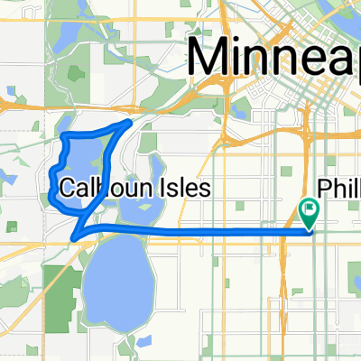
B2B 55413 > 55101 via East River Rd., Summit Ave.
A cycling route starting in Minneapolis, Minnesota, United States.
Overview
About this route
Do descriptions print?
- -:--
- Duration
- 19.2 km
- Distance
- 126 m
- Ascent
- 134 m
- Descent
- ---
- Avg. speed
- 291 m
- Max. altitude
Route quality
Waytypes & surfaces along the route
Waytypes
Road
9.2 km
(48 %)
Cycleway
4.4 km
(23 %)
Surfaces
Paved
16.1 km
(84 %)
Asphalt
9 km
(47 %)
Paved (undefined)
6.9 km
(36 %)
Route highlights
Points of interest along the route
Point of interest after 2.3 km
Begin bike lane & One way street.
Point of interest after 3.3 km
Bike/Ped Bridge
Point of interest after 4.8 km
Moderate traffic on Oak Street. Use sidewalks if uncomfortable.
Point of interest after 9.8 km
End of Bike Path. Moderate car traffic on Cretin. Use sidewalk until Summit Ave. if uncomfortable.
Point of interest after 18 km
Shortcut through parking lot.
Point of interest after 18.4 km
Moderate car traffic. Walk bike on sidewalk if uncomfortable riding in car lane.
Continue with Bikemap
Use, edit, or download this cycling route
You would like to ride B2B 55413 > 55101 via East River Rd., Summit Ave. or customize it for your own trip? Here is what you can do with this Bikemap route:
Free features
- Save this route as favorite or in collections
- Copy & plan your own version of this route
- Sync your route with Garmin or Wahoo
Premium features
Free trial for 3 days, or one-time payment. More about Bikemap Premium.
- Navigate this route on iOS & Android
- Export a GPX / KML file of this route
- Create your custom printout (try it for free)
- Download this route for offline navigation
Discover more Premium features.
Get Bikemap PremiumFrom our community
Other popular routes starting in Minneapolis
 TCAC Cedar Lake Loop
- Distance
- 15.9 km
- Ascent
- 55 m
- Descent
- 54 m
- Location
- Minneapolis, Minnesota, United States
 East/West River Ride
- Distance
- 22.6 km
- Ascent
- 216 m
- Descent
- 217 m
- Location
- Minneapolis, Minnesota, United States
 30 Miles
- Distance
- 46.5 km
- Ascent
- 122 m
- Descent
- 142 m
- Location
- Minneapolis, Minnesota, United States
 1500–1562 Spruce Pl, Minneapolis to 1512 Spruce Pl, Minneapolis
- Distance
- 25 km
- Ascent
- 106 m
- Descent
- 107 m
- Location
- Minneapolis, Minnesota, United States
 S Sixth St, Minneapolis to Spruce Pl, Minneapolis
- Distance
- 1.7 km
- Ascent
- 6 m
- Descent
- 21 m
- Location
- Minneapolis, Minnesota, United States
 6-3 On East And West River Parkway
- Distance
- 21.4 km
- Ascent
- 245 m
- Descent
- 248 m
- Location
- Minneapolis, Minnesota, United States
 Three Lakes
- Distance
- 15.9 km
- Ascent
- 55 m
- Descent
- 56 m
- Location
- Minneapolis, Minnesota, United States
 B2B00941 55405>55410 via Cedar Lake Trl, Lakes
- Distance
- 11.2 km
- Ascent
- 77 m
- Descent
- 69 m
- Location
- Minneapolis, Minnesota, United States
Open it in the app