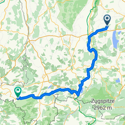
Erweitere Ammerseerunde ab Geltendorf
A cycling route starting in Eresing, Bavaria, Germany.
Overview
About this route
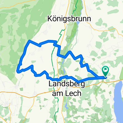
The route runs mainly on lightly trafficked state roads through the districts of Landsberg and Starnberg.Highlights of the round are the St. Ottilien Monastery and the Andechs Monastery, which invites you to take a short break halfway through. The route is somewhat hilly with a longer climb to Andechs. For those with average fitness, these can be managed without problems.
Departure and arrival are directly at the Geltendorf S-Bahn station. From Munich Central Station, it takes about 40 minutes by S-Bahn.
Have fun!
- -:--
- Duration
- 79 km
- Distance
- 514 m
- Ascent
- 514 m
- Descent
- ---
- Avg. speed
- ---
- Max. altitude
Route quality
Waytypes & surfaces along the route
Waytypes
- Road - 20.5 km - (26 %) 
- Quiet road - 19 km - (24 %) 
Surfaces
Paved
78.2 km
(99 %)
Unpaved
0.8 km
(1 %)
- Asphalt - 78.2 km - (99 %) 
- Pebblestone - 0.8 km - (1 %) 
Continue with Bikemap
Use, edit, or download this cycling route
You would like to ride Erweitere Ammerseerunde ab Geltendorf or customize it for your own trip? Here is what you can do with this Bikemap route:
Free features
- Save this route as favorite or in collections
- Copy & plan your own version of this route
- Sync your route with Garmin or Wahoo
Premium features
Free trial for 3 days, or one-time payment. More about Bikemap Premium.
- Navigate this route on iOS & Android
- Export a GPX / KML file of this route
- Create your custom printout (try it for free)
- Download this route for offline navigation
Discover more Premium features.
Get Bikemap PremiumFrom our community
Other popular routes starting in Eresing
 Greifenberger Straße nach Sudetenstraße Greifenberger Straße nach Sudetenstraße- Distance
- 97.5 km
- Ascent
- 428 m
- Descent
- 473 m
- Location
- Eresing, Bavaria, Germany
 
 Eresing - Hohenpeissenberg Eresing - Hohenpeissenberg- Distance
- 48.9 km
- Ascent
- 650 m
- Descent
- 276 m
- Location
- Eresing, Bavaria, Germany
 
 Ammerseerunde Hauptstraße 31, Eresing nach Landsberger Straße 64, Inning am Ammersee Ammerseerunde Hauptstraße 31, Eresing nach Landsberger Straße 64, Inning am Ammersee- Distance
- 50.9 km
- Ascent
- 240 m
- Descent
- 289 m
- Location
- Eresing, Bavaria, Germany
 
 48.104, 10.988 - 48.103, 10.980 48.104, 10.988 - 48.103, 10.980- Distance
- 56.2 km
- Ascent
- 384 m
- Descent
- 335 m
- Location
- Eresing, Bavaria, Germany
 
 Eresing nach St. Ottilien Eresing nach St. Ottilien- Distance
- 2.9 km
- Ascent
- 13 m
- Descent
- 16 m
- Location
- Eresing, Bavaria, Germany
 
 Von Eresing bis Füssen Von Eresing bis Füssen- Distance
- 93.2 km
- Ascent
- 819 m
- Descent
- 613 m
- Location
- Eresing, Bavaria, Germany
 
 Rennrad 67 km Rennrad 67 km- Distance
- 67.6 km
- Ascent
- 228 m
- Descent
- 228 m
- Location
- Eresing, Bavaria, Germany
 
 Geltendorf - Hechendorf Geltendorf - Hechendorf- Distance
- 19.3 km
- Ascent
- 151 m
- Descent
- 207 m
- Location
- Eresing, Bavaria, Germany
 
Open it in the app

