

Traun-Gmunden R4
A cycling route starting in Traun, Upper Austria, Austria.
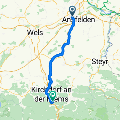
Overview
About this route
Still in progress!!!
- -:--
- Duration
- 57.8 km
- Distance
- 284 m
- Ascent
- 128 m
- Descent
- ---
- Avg. speed
- ---
- Max. altitude
Continue with Bikemap
Use, edit, or download this cycling route
You would like to ride Traun-Gmunden R4 or customize it for your own trip? Here is what you can do with this Bikemap route:
Free features
- Save this route as favorite or in collections
- Copy & plan your own version of this route
- Sync your route with Garmin or Wahoo
Premium features
Free trial for 3 days, or one-time payment. More about Bikemap Premium.
- Navigate this route on iOS & Android
- Export a GPX / KML file of this route
- Create your custom printout (try it for free)
- Download this route for offline navigation
Discover more Premium features.
Get Bikemap PremiumFrom our community
Other popular routes starting in Traun
 Fähre Mauthausen
- Distance
- 53.9 km
- Ascent
- 384 m
- Descent
- 383 m
- Location
- Traun, Upper Austria, Austria
 Lessingstraße 3, Traun nach Lessingstraße 1, Traun
- Distance
- 7.5 km
- Ascent
- 36 m
- Descent
- 51 m
- Location
- Traun, Upper Austria, Austria
 Kremstalradweg R10
- Distance
- 53.6 km
- Ascent
- 375 m
- Descent
- 185 m
- Location
- Traun, Upper Austria, Austria
 Ansfelden Wien
- Distance
- 229 km
- Ascent
- 947 m
- Descent
- 1,018 m
- Location
- Traun, Upper Austria, Austria
 Marchtrenk Runde
- Distance
- 24.9 km
- Ascent
- 47 m
- Descent
- 42 m
- Location
- Traun, Upper Austria, Austria
 Traun goes Mühlviertel
- Distance
- 71.4 km
- Ascent
- 1,202 m
- Descent
- 1,190 m
- Location
- Traun, Upper Austria, Austria
 Traun-Ansfelden-Marchtrenk-Traun
- Distance
- 41.8 km
- Ascent
- 304 m
- Descent
- 297 m
- Location
- Traun, Upper Austria, Austria
 mit damili
- Distance
- 10.4 km
- Ascent
- 280 m
- Descent
- 288 m
- Location
- Traun, Upper Austria, Austria
Open it in the app