

Mountainbike-Tour Ammersee-Ostufer
A cycling route starting in Jesenwang, Bavaria, Germany.
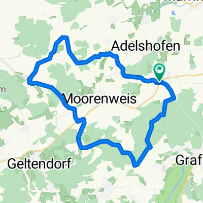
Overview
About this route
- -:--
- Duration
- 47.8 km
- Distance
- 239 m
- Ascent
- 239 m
- Descent
- ---
- Avg. speed
- ---
- Max. altitude
Route quality
Waytypes & surfaces along the route
Waytypes
Track
22.4 km
(47 %)
Quiet road
21 km
(44 %)
Surfaces
Paved
27.2 km
(57 %)
Unpaved
19.1 km
(40 %)
Asphalt
24.4 km
(51 %)
Gravel
11.9 km
(25 %)
Route highlights
Points of interest along the route
Point of interest after 47.7 km
Continue with Bikemap
Use, edit, or download this cycling route
You would like to ride Mountainbike-Tour Ammersee-Ostufer or customize it for your own trip? Here is what you can do with this Bikemap route:
Free features
- Save this route as favorite or in collections
- Copy & plan your own version of this route
- Sync your route with Garmin or Wahoo
Premium features
Free trial for 3 days, or one-time payment. More about Bikemap Premium.
- Navigate this route on iOS & Android
- Export a GPX / KML file of this route
- Create your custom printout (try it for free)
- Download this route for offline navigation
Discover more Premium features.
Get Bikemap PremiumFrom our community
Other popular routes starting in Jesenwang
 Ammerseerunde/ Golfpatz Pähl/ Andechs
- Distance
- 100.9 km
- Ascent
- 415 m
- Descent
- 413 m
- Location
- Jesenwang, Bavaria, Germany
 Grafrather Straße 4, Jesenwang nach Kirchstraße 20, Jesenwang
- Distance
- 10.8 km
- Ascent
- 77 m
- Descent
- 79 m
- Location
- Jesenwang, Bavaria, Germany
 JE W 12+80; Hofcafe Eresing
- Distance
- 12.8 km
- Ascent
- 105 m
- Descent
- 122 m
- Location
- Jesenwang, Bavaria, Germany
 Mountainbike-Tour Ammersee-Ostufer
- Distance
- 47.8 km
- Ascent
- 239 m
- Descent
- 239 m
- Location
- Jesenwang, Bavaria, Germany
 JE R 86+500 Kissing-St. Ottilien
- Distance
- 85.9 km
- Ascent
- 646 m
- Descent
- 644 m
- Location
- Jesenwang, Bavaria, Germany
 Abstecher Josef
- Distance
- 29.8 km
- Ascent
- 242 m
- Descent
- 245 m
- Location
- Jesenwang, Bavaria, Germany
 Abstecher zum Heide-Volm Planegg
- Distance
- 92.9 km
- Ascent
- 247 m
- Descent
- 244 m
- Location
- Jesenwang, Bavaria, Germany
 Kirchstraße 22, Jesenwang nach Kirchstraße 22, Jesenwang
- Distance
- 25.3 km
- Ascent
- 118 m
- Descent
- 116 m
- Location
- Jesenwang, Bavaria, Germany
Open it in the app