

Rheinroute
A cycling route starting in Rheinstetten, Baden-Wurttemberg, Germany.
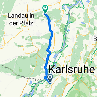
Overview
About this route
Beautiful, flat route through the villages and along the Rhine. Everything is paved.
- -:--
- Duration
- 80.5 km
- Distance
- 122 m
- Ascent
- 123 m
- Descent
- ---
- Avg. speed
- 125 m
- Max. altitude
Route quality
Waytypes & surfaces along the route
Waytypes
Track
16.9 km
(21 %)
Road
14.5 km
(18 %)
Surfaces
Paved
61.2 km
(76 %)
Unpaved
12.1 km
(15 %)
Asphalt
59.6 km
(74 %)
Gravel
9.7 km
(12 %)
Continue with Bikemap
Use, edit, or download this cycling route
You would like to ride Rheinroute or customize it for your own trip? Here is what you can do with this Bikemap route:
Free features
- Save this route as favorite or in collections
- Copy & plan your own version of this route
- Split it into stages to create a multi-day tour
- Sync your route with Garmin or Wahoo
Premium features
Free trial for 3 days, or one-time payment. More about Bikemap Premium.
- Navigate this route on iOS & Android
- Export a GPX / KML file of this route
- Create your custom printout (try it for free)
- Download this route for offline navigation
Discover more Premium features.
Get Bikemap PremiumFrom our community
Other popular routes starting in Rheinstetten
 Schluttenbachrunde
- Distance
- 32.6 km
- Ascent
- 290 m
- Descent
- 286 m
- Location
- Rheinstetten, Baden-Wurttemberg, Germany
 RTF Concordia Forchheim (154 KM)
- Distance
- 153.2 km
- Ascent
- 3,630 m
- Descent
- 3,600 m
- Location
- Rheinstetten, Baden-Wurttemberg, Germany
 Badische Eröffnungsfahrt - RTF des RSV Concordia 1920 Forchheim e.V. - 76 km Strecke
- Distance
- 76.5 km
- Ascent
- 325 m
- Descent
- 325 m
- Location
- Rheinstetten, Baden-Wurttemberg, Germany
 aus Rheinstetten in den Kraichgau mit Ortsdurchfahrten von Forchheim - KA Daxlanden - KA Knielingen - Eggenstein - Leopoldshafen - Staffort - Untergrombach - Ob
- Distance
- 112.2 km
- Ascent
- 420 m
- Descent
- 418 m
- Location
- Rheinstetten, Baden-Wurttemberg, Germany
 Frankreichrunde
- Distance
- 70.8 km
- Ascent
- 64 m
- Descent
- 66 m
- Location
- Rheinstetten, Baden-Wurttemberg, Germany
 Radrunde Durmersheim - Rheinstetten
- Distance
- 19 km
- Ascent
- 19 m
- Descent
- 19 m
- Location
- Rheinstetten, Baden-Wurttemberg, Germany
 RR -Verkehrsarme " Fünf Täler Rundtour" - Rheintal, Albtal, Eyachtal, Enztal & Murgtal.
- Distance
- 104.7 km
- Ascent
- 1,027 m
- Descent
- 1,029 m
- Location
- Rheinstetten, Baden-Wurttemberg, Germany
 nach zeiskam
- Distance
- 37.3 km
- Ascent
- 146 m
- Descent
- 134 m
- Location
- Rheinstetten, Baden-Wurttemberg, Germany
Open it in the app