

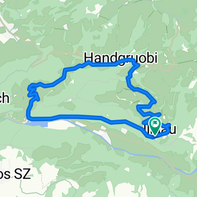
BIKE Pragelpass-Schwialppass-Sattelegg
A cycling route starting in Muotathal, Canton of Schwyz, Switzerland.
Overview
About this route
In Muotathal erst um 14:00 losgefahren, um 20:00 in Biberbrugg angekommen, wo Karin mich aufgesammelt hat.
Vom Pragelpass bis zum Schwialppass mühsam; fast alles geschoben/getragen.- -:--
- Duration
- 49.1 km
- Distance
- 1,592 m
- Ascent
- 1,427 m
- Descent
- ---
- Avg. speed
- ---
- Avg. speed
Route highlights
Points of interest along the route
Point of interest after 14 km
Vom Pragelpass vielleicht besser bis hier (1289m) abfahren, dann links hoch ...
Point of interest after 15.2 km
... über 'Under', 'Mittler' zur 'Oberen Schwialp' (1547m). Wäre vielleicht angenehmer.
Continue with Bikemap
Use, edit, or download this cycling route
You would like to ride BIKE Pragelpass-Schwialppass-Sattelegg or customize it for your own trip? Here is what you can do with this Bikemap route:
Free features
- Save this route as favorite or in collections
- Copy & plan your own version of this route
- Sync your route with Garmin or Wahoo
Premium features
Free trial for 3 days, or one-time payment. More about Bikemap Premium.
- Navigate this route on iOS & Android
- Export a GPX / KML file of this route
- Create your custom printout (try it for free)
- Download this route for offline navigation
Discover more Premium features.
Get Bikemap PremiumFrom our community
Other popular routes starting in Muotathal
 Klausenpass Rückfahrt
- Distance
- 166.7 km
- Ascent
- 1,495 m
- Descent
- 2,929 m
- Location
- Muotathal, Canton of Schwyz, Switzerland
 Pragelpass_Klausenpass (ironm)
- Distance
- 67.7 km
- Ascent
- 1,797 m
- Descent
- 1,388 m
- Location
- Muotathal, Canton of Schwyz, Switzerland
 Muotathal Chinzig Dottenriet
- Distance
- 60.7 km
- Ascent
- 2,014 m
- Descent
- 2,435 m
- Location
- Muotathal, Canton of Schwyz, Switzerland
 Route im Schneckentempo in Glarus
- Distance
- 18.9 km
- Ascent
- 69 m
- Descent
- 1,109 m
- Location
- Muotathal, Canton of Schwyz, Switzerland
 Schächental Bike
- Distance
- 55.9 km
- Ascent
- 1,916 m
- Descent
- 1,739 m
- Location
- Muotathal, Canton of Schwyz, Switzerland
 Illgau - Aufiberg
- Distance
- 14.8 km
- Ascent
- 630 m
- Descent
- 630 m
- Location
- Muotathal, Canton of Schwyz, Switzerland
 Muotathal - Uznach - Küsnacht
- Distance
- 97.1 km
- Ascent
- 1,430 m
- Descent
- 1,604 m
- Location
- Muotathal, Canton of Schwyz, Switzerland
 WanderWunder Schwyz: Rundwanderung Muotathal mit Plattenweg
- Distance
- 13.3 km
- Ascent
- 1,033 m
- Descent
- 1,031 m
- Location
- Muotathal, Canton of Schwyz, Switzerland
Open it in the app