
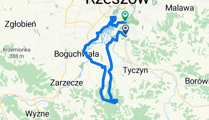
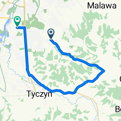
Zalesie- Przylasek- Boguchwała- Lisia góra
A cycling route starting in Tyczyn, Subcarpathian Voivodeship, Poland.
Overview
About this route
- -:--
- Duration
- 30.5 km
- Distance
- 252 m
- Ascent
- 256 m
- Descent
- ---
- Avg. speed
- ---
- Max. altitude
Route highlights
Points of interest along the route
Point of interest after 10.8 km
Źródełko w Przylasku
Continue with Bikemap
Use, edit, or download this cycling route
You would like to ride Zalesie- Przylasek- Boguchwała- Lisia góra or customize it for your own trip? Here is what you can do with this Bikemap route:
Free features
- Save this route as favorite or in collections
- Copy & plan your own version of this route
- Sync your route with Garmin or Wahoo
Premium features
Free trial for 3 days, or one-time payment. More about Bikemap Premium.
- Navigate this route on iOS & Android
- Export a GPX / KML file of this route
- Create your custom printout (try it for free)
- Download this route for offline navigation
Discover more Premium features.
Get Bikemap PremiumFrom our community
Other popular routes starting in Tyczyn
 Zalesie-Kraczkowa-Albigowa-Borówki-Chmielnik
- Distance
- 49.3 km
- Ascent
- 492 m
- Descent
- 465 m
- Location
- Tyczyn, Subcarpathian Voivodeship, Poland
 Dookola Patrii
- Distance
- 63 km
- Ascent
- 660 m
- Descent
- 682 m
- Location
- Tyczyn, Subcarpathian Voivodeship, Poland
 Niedzielna trasa v1
- Distance
- 11.5 km
- Ascent
- 77 m
- Descent
- 77 m
- Location
- Tyczyn, Subcarpathian Voivodeship, Poland
 Wielka Pętla wokół Rzeszowa
- Distance
- 159.2 km
- Ascent
- 846 m
- Descent
- 853 m
- Location
- Tyczyn, Subcarpathian Voivodeship, Poland
 Odkrywając nowe asfalty wokół Rzeszowa CLONED FROM ROUTE 440448
- Distance
- 113.4 km
- Ascent
- 976 m
- Descent
- 1,095 m
- Location
- Tyczyn, Subcarpathian Voivodeship, Poland
 4A, Matysówka do Zaciszna 5, Rzeszów
- Distance
- 16.9 km
- Ascent
- 124 m
- Descent
- 160 m
- Location
- Tyczyn, Subcarpathian Voivodeship, Poland
 Matysówka nocą
- Distance
- 21.6 km
- Ascent
- 422 m
- Descent
- 417 m
- Location
- Tyczyn, Subcarpathian Voivodeship, Poland
 Dookoła Rzeszowa 2
- Distance
- 85.6 km
- Ascent
- 605 m
- Descent
- 605 m
- Location
- Tyczyn, Subcarpathian Voivodeship, Poland
Open it in the app