

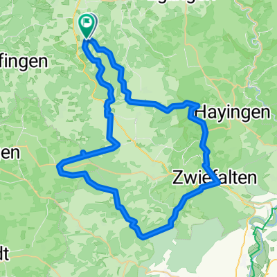
Kettenacker-Wimsener Höhle, Rennrad
A cycling route starting in Pfronstetten, Baden-Wurttemberg, Germany.
Overview
About this route
<p>Total elevation gain 771 m</p>
<p>little traffic</p>
<p>partly very secluded roads</p>
<p>great scenery</p>
<p></p>
Translated, show original (German)- -:--
- Duration
- 47.3 km
- Distance
- 455 m
- Ascent
- 458 m
- Descent
- ---
- Avg. speed
- ---
- Max. altitude
Route quality
Waytypes & surfaces along the route
Waytypes
Quiet road
16.1 km
(34 %)
Road
14.2 km
(30 %)
Surfaces
Paved
30.2 km
(64 %)
Unpaved
0.5 km
(1 %)
Asphalt
29.8 km
(63 %)
Paved (undefined)
0.5 km
(1 %)
Continue with Bikemap
Use, edit, or download this cycling route
You would like to ride Kettenacker-Wimsener Höhle, Rennrad or customize it for your own trip? Here is what you can do with this Bikemap route:
Free features
- Save this route as favorite or in collections
- Copy & plan your own version of this route
- Sync your route with Garmin or Wahoo
Premium features
Free trial for 3 days, or one-time payment. More about Bikemap Premium.
- Navigate this route on iOS & Android
- Export a GPX / KML file of this route
- Create your custom printout (try it for free)
- Download this route for offline navigation
Discover more Premium features.
Get Bikemap PremiumFrom our community
Other popular routes starting in Pfronstetten
 Tappa 9: Pfronstetten - Renningen
- Distance
- 82.5 km
- Ascent
- 476 m
- Descent
- 806 m
- Location
- Pfronstetten, Baden-Wurttemberg, Germany
 Tour 5 | Schafe, Honig und Schwarzwurst
- Distance
- 29.8 km
- Ascent
- 387 m
- Descent
- 391 m
- Location
- Pfronstetten, Baden-Wurttemberg, Germany
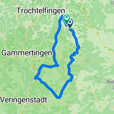
 Oberstetten-Kettenacker-Zwiefalten-Phäno
- Distance
- 51.7 km
- Ascent
- 1,185 m
- Descent
- 1,185 m
- Location
- Pfronstetten, Baden-Wurttemberg, Germany
 Kettenacker-Wimsener Höhle, Rennrad
- Distance
- 47.3 km
- Ascent
- 455 m
- Descent
- 458 m
- Location
- Pfronstetten, Baden-Wurttemberg, Germany
 От B312, Hohenstein до Kirchstraße 2, Hohenstein
- Distance
- 1.9 km
- Ascent
- 82 m
- Descent
- 47 m
- Location
- Pfronstetten, Baden-Wurttemberg, Germany
 K6739 nach K6739
- Distance
- 34.4 km
- Ascent
- 484 m
- Descent
- 490 m
- Location
- Pfronstetten, Baden-Wurttemberg, Germany
 10 Höfe Tour
- Distance
- 61.1 km
- Ascent
- 626 m
- Descent
- 634 m
- Location
- Pfronstetten, Baden-Wurttemberg, Germany
 Einfache Fahrt in Hohenstein
- Distance
- 7.9 km
- Ascent
- 267 m
- Descent
- 261 m
- Location
- Pfronstetten, Baden-Wurttemberg, Germany
Open it in the app