

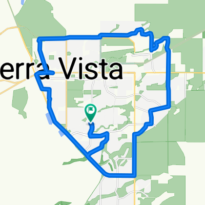
Bisbee via Palominas
A cycling route starting in Sierra Vista, Arizona, United States.
Overview
About this route
The incline through Palominas into Bisbee is not as drastic as going through the tunnel on HWY 80. Its a nice quiet ride with plenty of shoulder. There is a gas station in Palominas which is a nice place to water up if needed. I enjoy stopping off at one of the local restaurants for food before starting back. Be careful going through the tunnel as drivers fly through there and there is no shoulder. Enjoy!
- -:--
- Duration
- 110.5 km
- Distance
- 897 m
- Ascent
- 897 m
- Descent
- ---
- Avg. speed
- ---
- Max. altitude
Continue with Bikemap
Use, edit, or download this cycling route
You would like to ride Bisbee via Palominas or customize it for your own trip? Here is what you can do with this Bikemap route:
Free features
- Save this route as favorite or in collections
- Copy & plan your own version of this route
- Split it into stages to create a multi-day tour
- Sync your route with Garmin or Wahoo
Premium features
Free trial for 3 days, or one-time payment. More about Bikemap Premium.
- Navigate this route on iOS & Android
- Export a GPX / KML file of this route
- Create your custom printout (try it for free)
- Download this route for offline navigation
Discover more Premium features.
Get Bikemap PremiumFrom our community
Other popular routes starting in Sierra Vista
 Lexington Drive 1901, Sierra Vista to Lexington Drive 1901, Sierra Vista
- Distance
- 23.5 km
- Ascent
- 1,034 m
- Descent
- 1,035 m
- Location
- Sierra Vista, Arizona, United States
 Lexington Drive 1901, Sierra Vista to Lexington Drive 1901, Sierra Vista
- Distance
- 30.7 km
- Ascent
- 1,464 m
- Descent
- 1,466 m
- Location
- Sierra Vista, Arizona, United States
 Loop around Sierra Vista
- Distance
- 21.7 km
- Ascent
- 101 m
- Descent
- 101 m
- Location
- Sierra Vista, Arizona, United States
 bike tour through Sierra Vista
- Distance
- 17.1 km
- Ascent
- 100 m
- Descent
- 100 m
- Location
- Sierra Vista, Arizona, United States
 El Mercado Loop 2200, Sierra Vista to El Mercado Loop 2200, Sierra Vista
- Distance
- 15 km
- Ascent
- 73 m
- Descent
- 74 m
- Location
- Sierra Vista, Arizona, United States
 Copper Sky Drive 2533, Sierra Vista to Lexington Drive 1901, Sierra Vista
- Distance
- 33.9 km
- Ascent
- 915 m
- Descent
- 872 m
- Location
- Sierra Vista, Arizona, United States
 Lexington Drive 1901, Sierra Vista to Lexington Drive 1901, Sierra Vista
- Distance
- 23.3 km
- Ascent
- 512 m
- Descent
- 512 m
- Location
- Sierra Vista, Arizona, United States
 St. Andrews path
- Distance
- 12.6 km
- Ascent
- 92 m
- Descent
- 69 m
- Location
- Sierra Vista, Arizona, United States
Open it in the app