

CRI en Valencia
A cycling route starting in Alboraya, Valencia, Spain.
Overview
About this route
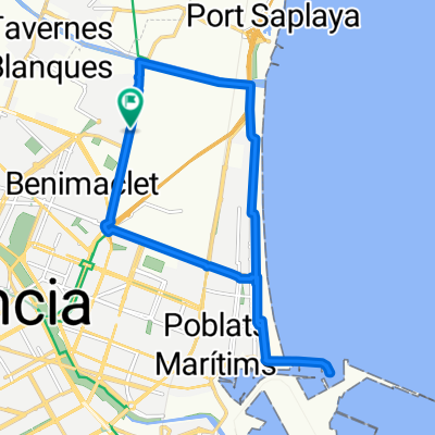
Departure from the Renfe station of Canbanyal to ride up the Serreria avenue. We arrive at the Port of Valencia, where you can see the famous docks, which are used as pits in F1. A tour through Nazaret to explore the old course of the Túria river. Later we enter the center via the avenue of Cid and circle the center of Valencia through the streets of Colón, Xàtiva, and Guillem de Castro, where the bullring and the economic center of the city are located. We return to the old course passing in front of the Serrano Towers, the site of the Cridà. We enter the center passing in front of the Basilica of the Virgin of the Abandoned. We enter through several streets and end at the door of the Cathedral of Valencia. All this in 22 km.
- -:--
- Duration
- 22.3 km
- Distance
- 90 m
- Ascent
- 72 m
- Descent
- ---
- Avg. speed
- ---
- Max. altitude
Route quality
Waytypes & surfaces along the route
Waytypes
Cycleway
7.6 km
(34 %)
Quiet road
2.7 km
(12 %)
Surfaces
Paved
14.5 km
(65 %)
Asphalt
13.6 km
(61 %)
Paved (undefined)
0.9 km
(4 %)
Undefined
7.8 km
(35 %)
Continue with Bikemap
Use, edit, or download this cycling route
You would like to ride CRI en Valencia or customize it for your own trip? Here is what you can do with this Bikemap route:
Free features
- Save this route as favorite or in collections
- Copy & plan your own version of this route
- Sync your route with Garmin or Wahoo
Premium features
Free trial for 3 days, or one-time payment. More about Bikemap Premium.
- Navigate this route on iOS & Android
- Export a GPX / KML file of this route
- Create your custom printout (try it for free)
- Download this route for offline navigation
Discover more Premium features.
Get Bikemap PremiumFrom our community
Other popular routes starting in Alboraya
 Valencia - Mola de Segart - Chocainet -Valencia
- Distance
- 56.4 km
- Ascent
- 640 m
- Descent
- 639 m
- Location
- Alboraya, Valencia, Spain
 alboraya,puerto,malvarrosa,alboraya
- Distance
- 15.4 km
- Ascent
- 34 m
- Descent
- 34 m
- Location
- Alboraya, Valencia, Spain
 20100514-Via Augusta y Raco de Gausa
- Distance
- 36.9 km
- Ascent
- 344 m
- Descent
- 227 m
- Location
- Alboraya, Valencia, Spain
 Valencia-Gandía-Alcoi
- Distance
- 122.2 km
- Ascent
- 761 m
- Descent
- 208 m
- Location
- Alboraya, Valencia, Spain
 VALENCIA TRIATLÓN 2017 - CAMPEONATO DE ESPAÑA ELITE
- Distance
- 5.8 km
- Ascent
- 28 m
- Descent
- 26 m
- Location
- Alboraya, Valencia, Spain
 2 x Domingo 29-02
- Distance
- 12.2 km
- Ascent
- 306 m
- Descent
- 289 m
- Location
- Alboraya, Valencia, Spain
 VUELTA 2o1o - Valencia/Weinheim
- Distance
- 1,789.9 km
- Ascent
- 878 m
- Descent
- 789 m
- Location
- Alboraya, Valencia, Spain
 Valencia-Sot de Chera
- Distance
- 199.1 km
- Ascent
- 1,283 m
- Descent
- 1,284 m
- Location
- Alboraya, Valencia, Spain
Open it in the app