

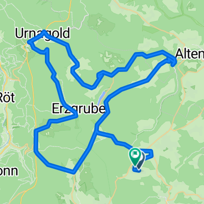
lützenhardt-leinstetten
A cycling route starting in Pfalzgrafenweiler, Baden-Wurttemberg, Germany.
Overview
About this route
- -:--
- Duration
- 17.4 km
- Distance
- 280 m
- Ascent
- 328 m
- Descent
- ---
- Avg. speed
- 683 m
- Max. altitude
Route quality
Waytypes & surfaces along the route
Waytypes
Road
7.5 km
(43 %)
Track
5.4 km
(31 %)
Surfaces
Paved
13.7 km
(79 %)
Unpaved
1.2 km
(7 %)
Asphalt
10.1 km
(58 %)
Paved (undefined)
3.7 km
(21 %)
Route highlights
Points of interest along the route
Point of interest after 9 km
Sportplatz
Continue with Bikemap
Use, edit, or download this cycling route
You would like to ride lützenhardt-leinstetten or customize it for your own trip? Here is what you can do with this Bikemap route:
Free features
- Save this route as favorite or in collections
- Copy & plan your own version of this route
- Sync your route with Garmin or Wahoo
Premium features
Free trial for 3 days, or one-time payment. More about Bikemap Premium.
- Navigate this route on iOS & Android
- Export a GPX / KML file of this route
- Create your custom printout (try it for free)
- Download this route for offline navigation
Discover more Premium features.
Get Bikemap PremiumFrom our community
Other popular routes starting in Pfalzgrafenweiler
 Etappe 2
- Distance
- 16.4 km
- Ascent
- 220 m
- Descent
- 387 m
- Location
- Pfalzgrafenweiler, Baden-Wurttemberg, Germany
 Nagoldtalsperre
- Distance
- 30.7 km
- Ascent
- 504 m
- Descent
- 504 m
- Location
- Pfalzgrafenweiler, Baden-Wurttemberg, Germany
 Waldwege1
- Distance
- 12.2 km
- Ascent
- 143 m
- Descent
- 143 m
- Location
- Pfalzgrafenweiler, Baden-Wurttemberg, Germany
 lützenhardt-leinstetten
- Distance
- 17.4 km
- Ascent
- 280 m
- Descent
- 328 m
- Location
- Pfalzgrafenweiler, Baden-Wurttemberg, Germany
 Schwarzwald - Herzogsweiler
- Distance
- 63.1 km
- Ascent
- 816 m
- Descent
- 810 m
- Location
- Pfalzgrafenweiler, Baden-Wurttemberg, Germany
 Radeln und Baden 2
- Distance
- 12.4 km
- Ascent
- 121 m
- Descent
- 119 m
- Location
- Pfalzgrafenweiler, Baden-Wurttemberg, Germany
 Richtung Musbach, dann Kälberbronn
- Distance
- 21 km
- Ascent
- 252 m
- Descent
- 251 m
- Location
- Pfalzgrafenweiler, Baden-Wurttemberg, Germany
 Edelweiler - Spielberg - Altensteig
- Distance
- 23.7 km
- Ascent
- 342 m
- Descent
- 342 m
- Location
- Pfalzgrafenweiler, Baden-Wurttemberg, Germany
Open it in the app