

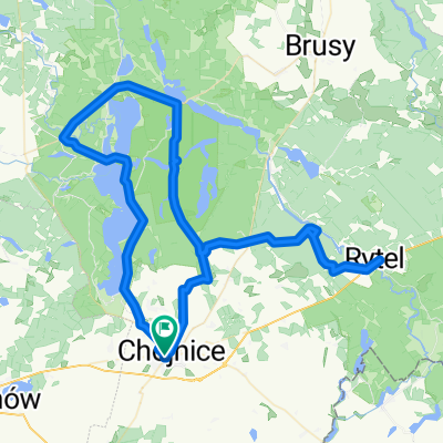
Chojnice - Czersk - Brusy - Swornegacie - Chojnice CLONED FROM ROUTE 1830523
A cycling route starting in Chojnice, Pomeranian Voivodeship, Poland.
Overview
About this route
- września 2012, 8.00 rano
- -:--
- Duration
- 124.4 km
- Distance
- 235 m
- Ascent
- 235 m
- Descent
- ---
- Avg. speed
- ---
- Max. altitude
Route quality
Waytypes & surfaces along the route
Waytypes
Road
58.5 km
(47 %)
Track
17.4 km
(14 %)
Surfaces
Paved
89.6 km
(72 %)
Unpaved
5 km
(4 %)
Asphalt
82.1 km
(66 %)
Paved (undefined)
7.5 km
(6 %)
Continue with Bikemap
Use, edit, or download this cycling route
You would like to ride Chojnice - Czersk - Brusy - Swornegacie - Chojnice CLONED FROM ROUTE 1830523 or customize it for your own trip? Here is what you can do with this Bikemap route:
Free features
- Save this route as favorite or in collections
- Copy & plan your own version of this route
- Split it into stages to create a multi-day tour
- Sync your route with Garmin or Wahoo
Premium features
Free trial for 3 days, or one-time payment. More about Bikemap Premium.
- Navigate this route on iOS & Android
- Export a GPX / KML file of this route
- Create your custom printout (try it for free)
- Download this route for offline navigation
Discover more Premium features.
Get Bikemap PremiumFrom our community
Other popular routes starting in Chojnice
 Chociński Młyn Bachorze Ch.M.
- Distance
- 13.4 km
- Ascent
- 107 m
- Descent
- 141 m
- Location
- Chojnice, Pomeranian Voivodeship, Poland
 Wyprawa nr 2
- Distance
- 49.9 km
- Ascent
- 163 m
- Descent
- 164 m
- Location
- Chojnice, Pomeranian Voivodeship, Poland
 Chojnicka, Małe Swornegacie do Chojnicka, Małe Swornegacie
- Distance
- 42.6 km
- Ascent
- 706 m
- Descent
- 706 m
- Location
- Chojnice, Pomeranian Voivodeship, Poland
 Ósemka Charzykowska
- Distance
- 49.6 km
- Ascent
- 251 m
- Descent
- 251 m
- Location
- Chojnice, Pomeranian Voivodeship, Poland
 Czarnoszyce
- Distance
- 14.5 km
- Ascent
- 118 m
- Descent
- 148 m
- Location
- Chojnice, Pomeranian Voivodeship, Poland
 Jezioro Charzykowskie
- Distance
- 40.7 km
- Ascent
- 219 m
- Descent
- 220 m
- Location
- Chojnice, Pomeranian Voivodeship, Poland
 Szlak Niebieski Parku Narodowego Borów Tucholskich
- Distance
- 84 km
- Ascent
- 244 m
- Descent
- 246 m
- Location
- Chojnice, Pomeranian Voivodeship, Poland
 po Parku Narodowym "Bory Tucholskie"
- Distance
- 31.9 km
- Ascent
- 155 m
- Descent
- 155 m
- Location
- Chojnice, Pomeranian Voivodeship, Poland
Open it in the app