

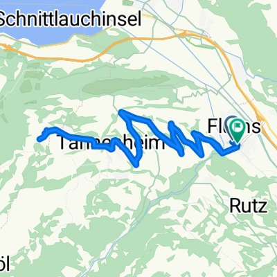
Flums - Flumserberg -Tannenbodenalp
A cycling route starting in Flums, Canton of St. Gallen, Switzerland.
Overview
About this route
Tour de Suisse Bergankunft 08
- -:--
- Duration
- 21.7 km
- Distance
- 1,003 m
- Ascent
- 855 m
- Descent
- ---
- Avg. speed
- 1,410 m
- Max. altitude
Route quality
Waytypes & surfaces along the route
Waytypes
Access road
1.1 km
(5 %)
Quiet road
0.9 km
(4 %)
Undefined
19.8 km
(91 %)
Surfaces
Paved
21.3 km
(98 %)
Asphalt
21.3 km
(98 %)
Undefined
0.4 km
(2 %)
Continue with Bikemap
Use, edit, or download this cycling route
You would like to ride Flums - Flumserberg -Tannenbodenalp or customize it for your own trip? Here is what you can do with this Bikemap route:
Free features
- Save this route as favorite or in collections
- Copy & plan your own version of this route
- Sync your route with Garmin or Wahoo
Premium features
Free trial for 3 days, or one-time payment. More about Bikemap Premium.
- Navigate this route on iOS & Android
- Export a GPX / KML file of this route
- Create your custom printout (try it for free)
- Download this route for offline navigation
Discover more Premium features.
Get Bikemap PremiumFrom our community
Other popular routes starting in Flums
 bike tour through Flumserberg Theim
- Distance
- 23.1 km
- Ascent
- 771 m
- Descent
- 770 m
- Location
- Flums, Canton of St. Gallen, Switzerland
 Grimms-Tour
- Distance
- 25.4 km
- Ascent
- 911 m
- Descent
- 914 m
- Location
- Flums, Canton of St. Gallen, Switzerland
 Flums - Flumserberg -Tannenbodenalp
- Distance
- 21.7 km
- Ascent
- 1,003 m
- Descent
- 855 m
- Location
- Flums, Canton of St. Gallen, Switzerland
 Flumserberg
- Distance
- 37.9 km
- Ascent
- 1,428 m
- Descent
- 1,428 m
- Location
- Flums, Canton of St. Gallen, Switzerland
 36 Flums - Alp Fursch - Flums (Nr. 478)
- Distance
- 36 km
- Ascent
- 1,390 m
- Descent
- 1,390 m
- Location
- Flums, Canton of St. Gallen, Switzerland
 Runde Flums-Flumserberg-Panüöl-Schilstal
- Distance
- 35.6 km
- Ascent
- 1,546 m
- Descent
- 1,545 m
- Location
- Flums, Canton of St. Gallen, Switzerland
 Cuhrfirstenunrundung
- Distance
- 133.5 km
- Ascent
- 1,234 m
- Descent
- 1,234 m
- Location
- Flums, Canton of St. Gallen, Switzerland
 Alp Panüöl, Flumserberg Theim nach Restaurant Molseralp, Flumserberg Tboden
- Distance
- 8.8 km
- Ascent
- 212 m
- Descent
- 449 m
- Location
- Flums, Canton of St. Gallen, Switzerland
Open it in the app