

GA1-Training (bei Gewitter/Regen/Nass)
A cycling route starting in Gommiswald, Canton of St. Gallen, Switzerland.
Overview
About this route
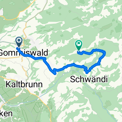
Original route adjusted to avoid a thunderstorm, hence a U-turn in Benken (at the first pass).
- -:--
- Duration
- 40.1 km
- Distance
- 227 m
- Ascent
- 227 m
- Descent
- ---
- Avg. speed
- ---
- Max. altitude

Route quality
Waytypes & surfaces along the route
Waytypes
Quiet road
8 km
(20 %)
Cycleway
3.6 km
(9 %)
Surfaces
Paved
26.5 km
(66 %)
Unpaved
0.4 km
(1 %)
Asphalt
26.1 km
(65 %)
Paved (undefined)
0.4 km
(1 %)
Continue with Bikemap
Use, edit, or download this cycling route
You would like to ride GA1-Training (bei Gewitter/Regen/Nass) or customize it for your own trip? Here is what you can do with this Bikemap route:
Free features
- Save this route as favorite or in collections
- Copy & plan your own version of this route
- Sync your route with Garmin or Wahoo
Premium features
Free trial for 3 days, or one-time payment. More about Bikemap Premium.
- Navigate this route on iOS & Android
- Export a GPX / KML file of this route
- Create your custom printout (try it for free)
- Download this route for offline navigation
Discover more Premium features.
Get Bikemap PremiumFrom our community
Other popular routes starting in Gommiswald
 Ricken SG, Rittmarren, Ernetschwil nach Ricken SG, Rittmarren, Ernetschwil
- Distance
- 37.9 km
- Ascent
- 1,204 m
- Descent
- 1,184 m
- Location
- Gommiswald, Canton of St. Gallen, Switzerland
 Mountainbike-Tour
- Distance
- 35.3 km
- Ascent
- 1,177 m
- Descent
- 1,174 m
- Location
- Gommiswald, Canton of St. Gallen, Switzerland
 Uetliburg - Farneren
- Distance
- 31.6 km
- Ascent
- 947 m
- Descent
- 948 m
- Location
- Gommiswald, Canton of St. Gallen, Switzerland
 Moderate Route in Gommiswald
- Distance
- 10.5 km
- Ascent
- 946 m
- Descent
- 320 m
- Location
- Gommiswald, Canton of St. Gallen, Switzerland
 Zürichseerundfahrt (95KM)
- Distance
- 95.8 km
- Ascent
- 250 m
- Descent
- 250 m
- Location
- Gommiswald, Canton of St. Gallen, Switzerland
 Test1
Test1- Distance
- 17.1 km
- Ascent
- 239 m
- Descent
- 338 m
- Location
- Gommiswald, Canton of St. Gallen, Switzerland
 Klausenpass-Rundfahrt
- Distance
- 162 km
- Ascent
- 2,207 m
- Descent
- 2,207 m
- Location
- Gommiswald, Canton of St. Gallen, Switzerland
 Ricken -Schwägalp - Oberried - Wildhaus - Ricken
- Distance
- 126.6 km
- Ascent
- 1,761 m
- Descent
- 1,761 m
- Location
- Gommiswald, Canton of St. Gallen, Switzerland
Open it in the app