

Silberberg-Gleinalmsattel CLONED FROM ROUTE 1829217
A cycling route starting in Sankt Radegund bei Graz, Styria, Austria.
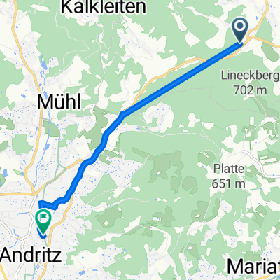
Overview
About this route
Silbergberg 913m
Gleinalmsattel 1586m!
- -:--
- Duration
- 98.2 km
- Distance
- 1,492 m
- Ascent
- 1,622 m
- Descent
- ---
- Avg. speed
- ---
- Max. altitude
Route quality
Waytypes & surfaces along the route
Waytypes
Track
22.6 km
(23 %)
Cycleway
12.8 km
(13 %)
Surfaces
Paved
70.7 km
(72 %)
Unpaved
22.6 km
(23 %)
Asphalt
70.7 km
(72 %)
Unpaved (undefined)
15.7 km
(16 %)
Continue with Bikemap
Use, edit, or download this cycling route
You would like to ride Silberberg-Gleinalmsattel CLONED FROM ROUTE 1829217 or customize it for your own trip? Here is what you can do with this Bikemap route:
Free features
- Save this route as favorite or in collections
- Copy & plan your own version of this route
- Split it into stages to create a multi-day tour
- Sync your route with Garmin or Wahoo
Premium features
Free trial for 3 days, or one-time payment. More about Bikemap Premium.
- Navigate this route on iOS & Android
- Export a GPX / KML file of this route
- Create your custom printout (try it for free)
- Download this route for offline navigation
Discover more Premium features.
Get Bikemap PremiumFrom our community
Other popular routes starting in Sankt Radegund bei Graz
 SCHÖCKL RUNDE SEMRIACH
- Distance
- 38.4 km
- Ascent
- 976 m
- Descent
- 976 m
- Location
- Sankt Radegund bei Graz, Styria, Austria
 RT11-Mariazell in 1,5 Tagen
- Distance
- 156.5 km
- Ascent
- 818 m
- Descent
- 193 m
- Location
- Sankt Radegund bei Graz, Styria, Austria
 Raabklamm 2
- Distance
- 34.2 km
- Ascent
- 615 m
- Descent
- 616 m
- Location
- Sankt Radegund bei Graz, Styria, Austria
 Rinneggerstraße 41, Oberschöckl to Hans-Mauracher-Straße 10, Graz
- Distance
- 5.5 km
- Ascent
- 4 m
- Descent
- 417 m
- Location
- Sankt Radegund bei Graz, Styria, Austria
 Schöckl-Runde von dahoam
- Distance
- 41.5 km
- Ascent
- 898 m
- Descent
- 933 m
- Location
- Sankt Radegund bei Graz, Styria, Austria
 Schökl
- Distance
- 10.1 km
- Ascent
- 669 m
- Descent
- 670 m
- Location
- Sankt Radegund bei Graz, Styria, Austria
 TR - Tage Leibnitz Ostern 2012
- Distance
- 489.3 km
- Ascent
- 1,575 m
- Descent
- 1,567 m
- Location
- Sankt Radegund bei Graz, Styria, Austria
 Radegund - Leber - Semriach - Rechberg - Tulwitz-Wölling-Plenzengreith-Schöcklkreuz
- Distance
- 51 km
- Ascent
- 1,588 m
- Descent
- 1,356 m
- Location
- Sankt Radegund bei Graz, Styria, Austria
Open it in the app