
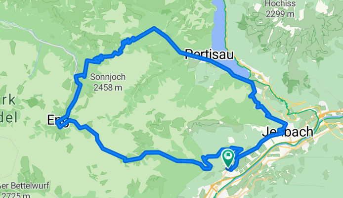
Felsbastionen Tour
A cycling route starting in Stans, Tyrol, Austria.
Overview
About this route
Tour from Mountainbike 08/2011
Karwendel Tour
- -:--
- Duration
- 56.5 km
- Distance
- 1,980 m
- Ascent
- 1,981 m
- Descent
- ---
- Avg. speed
- ---
- Max. altitude
Continue with Bikemap
Use, edit, or download this cycling route
You would like to ride Felsbastionen Tour or customize it for your own trip? Here is what you can do with this Bikemap route:
Free features
- Save this route as favorite or in collections
- Copy & plan your own version of this route
- Sync your route with Garmin or Wahoo
Premium features
Free trial for 3 days, or one-time payment. More about Bikemap Premium.
- Navigate this route on iOS & Android
- Export a GPX / KML file of this route
- Create your custom printout (try it for free)
- Download this route for offline navigation
Discover more Premium features.
Get Bikemap PremiumFrom our community
Other popular routes starting in Stans
 Pertisau - Leutasch
- Distance
- 51.3 km
- Ascent
- 1,056 m
- Descent
- 1,052 m
- Location
- Stans, Tyrol, Austria
 Zwoelferkopf Peak (Gipfel)- Pertisau Village (Dorf)
- Distance
- 7.7 km
- Ascent
- 155 m
- Descent
- 663 m
- Location
- Stans, Tyrol, Austria
 Stans - Fügen (über die Loas,Gamsstein)
- Distance
- 33.1 km
- Ascent
- 1,175 m
- Descent
- 1,192 m
- Location
- Stans, Tyrol, Austria
 Güterweg Heuberg, Stans nach Güterweg Heuberg, Stans
- Distance
- 1.7 km
- Ascent
- 162 m
- Descent
- 4 m
- Location
- Stans, Tyrol, Austria
 Zwoelferkopf- Pertisau Water's Edge (Vor dem See)
- Distance
- 14.2 km
- Ascent
- 441 m
- Descent
- 986 m
- Location
- Stans, Tyrol, Austria
 Naturschutzgebiet Karwendel nach Achenkirchen zurück
- Distance
- 14.4 km
- Ascent
- 192 m
- Descent
- 248 m
- Location
- Stans, Tyrol, Austria
 Felsbastionen Tour
- Distance
- 56.5 km
- Ascent
- 1,980 m
- Descent
- 1,981 m
- Location
- Stans, Tyrol, Austria
 auf den pendling
- Distance
- 68 km
- Ascent
- 1,076 m
- Descent
- 1,142 m
- Location
- Stans, Tyrol, Austria
Open it in the app