

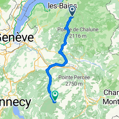
Col-de-Cou-Col-du Feu
A cycling route starting in Lyaud, Auvergne-Rhône-Alpes, France.
Overview
About this route
- -:--
- Duration
- 76.8 km
- Distance
- 1,192 m
- Ascent
- 1,395 m
- Descent
- ---
- Avg. speed
- ---
- Max. altitude

Route quality
Waytypes & surfaces along the route
Waytypes
Road
43 km
(56 %)
Busy road
15.6 km
(20 %)
Surfaces
Paved
60.8 km
(79 %)
Unpaved
1.3 km
(2 %)
Asphalt
60.5 km
(79 %)
Ground
0.9 km
(1 %)
Continue with Bikemap
Use, edit, or download this cycling route
You would like to ride Col-de-Cou-Col-du Feu or customize it for your own trip? Here is what you can do with this Bikemap route:
Free features
- Save this route as favorite or in collections
- Copy & plan your own version of this route
- Sync your route with Garmin or Wahoo
Premium features
Free trial for 3 days, or one-time payment. More about Bikemap Premium.
- Navigate this route on iOS & Android
- Export a GPX / KML file of this route
- Create your custom printout (try it for free)
- Download this route for offline navigation
Discover more Premium features.
Get Bikemap PremiumFrom our community
Other popular routes starting in Lyaud
 lyaud evian
- Distance
- 17.5 km
- Ascent
- 158 m
- Descent
- 367 m
- Location
- Lyaud, Auvergne-Rhône-Alpes, France
 spiagge thonon
- Distance
- 38.9 km
- Ascent
- 403 m
- Descent
- 403 m
- Location
- Lyaud, Auvergne-Rhône-Alpes, France
 sortie velo outrebrevon 1
- Distance
- 39.4 km
- Ascent
- 1,175 m
- Descent
- 1,195 m
- Location
- Lyaud, Auvergne-Rhône-Alpes, France
 Frankreich Tag 1
- Distance
- 66.7 km
- Ascent
- 1,114 m
- Descent
- 842 m
- Location
- Lyaud, Auvergne-Rhône-Alpes, France
 mont riot
- Distance
- 10.3 km
- Ascent
- 298 m
- Descent
- 50 m
- Location
- Lyaud, Auvergne-Rhône-Alpes, France
 haver poche
- Distance
- 8.7 km
- Ascent
- 334 m
- Descent
- 14 m
- Location
- Lyaud, Auvergne-Rhône-Alpes, France
 thonon centro
- Distance
- 6.9 km
- Ascent
- 9 m
- Descent
- 168 m
- Location
- Lyaud, Auvergne-Rhône-Alpes, France
 Col-de-Cou-Col-du Feu
- Distance
- 76.8 km
- Ascent
- 1,192 m
- Descent
- 1,395 m
- Location
- Lyaud, Auvergne-Rhône-Alpes, France
Open it in the app