RUTA MTB ANTENAS-PINILLA-COPE
A cycling route starting in Águilas, Murcia, Spain.
Overview
About this route
AGUILAS-RAMBLA DE PAÑARANDA-POLIDEPORTIVO-BP-CAMINO DE LOS MELENCHONES-BARRANCO DE LA PALOMA-COLLADO DE LA PALOMA-COLLADO DE LA CABRA Y SUBIDA ANTENAS O CABEZO DE LOS MAYORALES (690 M)-BAJADA A CUESTA DE GOS-RAMBLA DE CUESTA DE GOS-RAMBLA DE PINILLA-SUBIDA COLLADO DE PINILLA (670 M)-BAJADA DE PINILLA-RAMBLA DE EL GARROBILLO-CALA BLANCA-CALAS DEL PARQUE NATURAL DE CABO COPE-COPE-CALABARDINA-SENDA DE TODOSOL LOS COLLADOS Y WEISS-EL FRAILE-DECATLHON-AGUILAS.
- -:--
- Duration
- 65.4 km
- Distance
- 1,128 m
- Ascent
- 1,128 m
- Descent
- ---
- Avg. speed
- ---
- Avg. speed
Continue with Bikemap
Use, edit, or download this cycling route
You would like to ride RUTA MTB ANTENAS-PINILLA-COPE or customize it for your own trip? Here is what you can do with this Bikemap route:
Free features
- Save this route as favorite or in collections
- Copy & plan your own version of this route
- Sync your route with Garmin or Wahoo
Premium features
Free trial for 3 days, or one-time payment. More about Bikemap Premium.
- Navigate this route on iOS & Android
- Export a GPX / KML file of this route
- Create your custom printout (try it for free)
- Download this route for offline navigation
Discover more Premium features.
Get Bikemap PremiumFrom our community
Other popular routes starting in Águilas
- Playa Carolina- SanJuan- Castillos de los Terreros und retour
- Distance
- 10.7 km
- Ascent
- 158 m
- Descent
- 158 m
- Location
- Águilas, Murcia, Spain
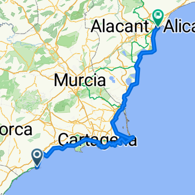
- I Maratón de Águilas
- Distance
- 54.8 km
- Ascent
- 924 m
- Descent
- 925 m
- Location
- Águilas, Murcia, Spain
- MTB COLLADO SIERRA MAYORALES
- Distance
- 52.9 km
- Ascent
- 835 m
- Descent
- 835 m
- Location
- Águilas, Murcia, Spain
- RUTA MTB ANTENAS-PINILLA-COPE
- Distance
- 65.4 km
- Ascent
- 1,128 m
- Descent
- 1,128 m
- Location
- Águilas, Murcia, Spain
- LOS MAYORALES, por Las Casicas
- Distance
- 9 km
- Ascent
- 528 m
- Descent
- 28 m
- Location
- Águilas, Murcia, Spain
- De Lugar Majada del Moro 4, Águilas a Lugar Majada del Moro 4, Águilas
- Distance
- 15.1 km
- Ascent
- 402 m
- Descent
- 375 m
- Location
- Águilas, Murcia, Spain
- TORRE CABO COPE - ALICANTE - 275
- Distance
- 275.3 km
- Ascent
- 1,073 m
- Descent
- 1,034 m
- Location
- Águilas, Murcia, Spain
- AGUILAS A LORCA
- Distance
- 36.3 km
- Ascent
- 598 m
- Descent
- 299 m
- Location
- Águilas, Murcia, Spain
Open it in the app