

Recreational Trails Map - Gateway Country - Route 5
A cycling route starting in Prince Edward, Ontario, Canada.
Overview
About this route
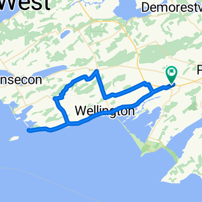
I just traced the route as outlined to get a reading on the distance because it was not included on the Recreational Trails Map (a large oversite in my opinion). The description given:<br />Picton - Sand Banks Loop - This is the beach tour, so be prpared for traffic on the weekends. Head west out of Picton on Hwy 33 to CR10 and follow south to Cherry Valley. Hug the shore of East Lake. At Salmon Point, turn right and pass through The Outlet and over to Sandbanks PP, or West Lake, as you chosse. Head back up West Lake Rd to the pretty village of Bloomfield, featuring a vibrant main street. Return to Picton along Hwy33. Generally flat, a few rolling hills on the last stretch.<br /><br /><br />If we bike it, I will add details.
- -:--
- Duration
- 40.4 km
- Distance
- 107 m
- Ascent
- 109 m
- Descent
- ---
- Avg. speed
- ---
- Max. altitude
Continue with Bikemap
Use, edit, or download this cycling route
You would like to ride Recreational Trails Map - Gateway Country - Route 5 or customize it for your own trip? Here is what you can do with this Bikemap route:
Free features
- Save this route as favorite or in collections
- Copy & plan your own version of this route
- Sync your route with Garmin or Wahoo
Premium features
Free trial for 3 days, or one-time payment. More about Bikemap Premium.
- Navigate this route on iOS & Android
- Export a GPX / KML file of this route
- Create your custom printout (try it for free)
- Download this route for offline navigation
Discover more Premium features.
Get Bikemap PremiumFrom our community
Other popular routes starting in Prince Edward
 Wellington Brighton Wellington
- Distance
- 90.9 km
- Ascent
- 204 m
- Descent
- 205 m
- Location
- Prince Edward, Ontario, Canada
 classic western wine route
- Distance
- 59.9 km
- Ascent
- 76 m
- Descent
- 76 m
- Location
- Prince Edward, Ontario, Canada
 canada day 100k
- Distance
- 104.5 km
- Ascent
- 126 m
- Descent
- 126 m
- Location
- Prince Edward, Ontario, Canada
 Corto fondo
- Distance
- 47.2 km
- Ascent
- 111 m
- Descent
- 111 m
- Location
- Prince Edward, Ontario, Canada
 swamp college to church camp
- Distance
- 33.4 km
- Ascent
- 62 m
- Descent
- 60 m
- Location
- Prince Edward, Ontario, Canada
 randonnée de vacance
- Distance
- 60.7 km
- Ascent
- 241 m
- Descent
- 238 m
- Location
- Prince Edward, Ontario, Canada
 Bloomfield to County Cider Factory and back
- Distance
- 65.7 km
- Ascent
- 261 m
- Descent
- 261 m
- Location
- Prince Edward, Ontario, Canada
 May 17, 2015, 3:28 PM
- Distance
- 38.3 km
- Ascent
- 110 m
- Descent
- 109 m
- Location
- Prince Edward, Ontario, Canada
Open it in the app