

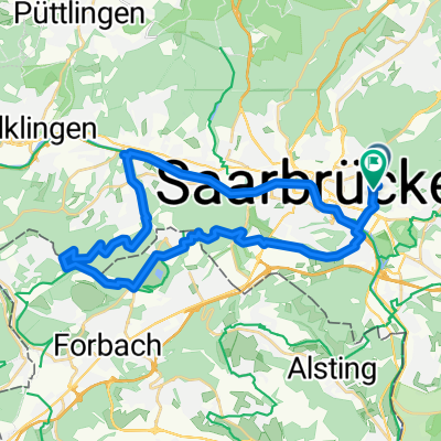
Sarre-Union
A cycling route starting in Saarbrücken, Saarland, Germany.
Overview
About this route
Ne große Runde nach Saare-Union, anfangs bergig, dann hüglig, dann flach:
SB - Deutschherrental - Spicheren - Etzling - Kerbach - Metzing - Puttelange-aux-Lacs - Sarralbe - Harskirchen - Sarre-Union - Keskastel - Herbitzheim - Zetting - an Saar und Kanal zurück nach SB
- -:--
- Duration
- 98.2 km
- Distance
- 402 m
- Ascent
- 402 m
- Descent
- ---
- Avg. speed
- ---
- Max. altitude

Route quality
Waytypes & surfaces along the route
Waytypes
Road
27.5 km
(28 %)
Access road
16.7 km
(17 %)
Surfaces
Paved
68.8 km
(70 %)
Unpaved
1 km
(1 %)
Asphalt
61.9 km
(63 %)
Paved (undefined)
4.9 km
(5 %)
Continue with Bikemap
Use, edit, or download this cycling route
You would like to ride Sarre-Union or customize it for your own trip? Here is what you can do with this Bikemap route:
Free features
- Save this route as favorite or in collections
- Copy & plan your own version of this route
- Split it into stages to create a multi-day tour
- Sync your route with Garmin or Wahoo
Premium features
Free trial for 3 days, or one-time payment. More about Bikemap Premium.
- Navigate this route on iOS & Android
- Export a GPX / KML file of this route
- Create your custom printout (try it for free)
- Download this route for offline navigation
Discover more Premium features.
Get Bikemap PremiumFrom our community
Other popular routes starting in Saarbrücken
 35 km Runde SB-Schoeneck-Neu-Aschbach, Leinpfadhschbach
- Distance
- 34.7 km
- Ascent
- 422 m
- Descent
- 436 m
- Location
- Saarbrücken, Saarland, Germany
 Coal Mining South of the Saar - 16 Tower Tour
- Distance
- 61.8 km
- Ascent
- 582 m
- Descent
- 581 m
- Location
- Saarbrücken, Saarland, Germany
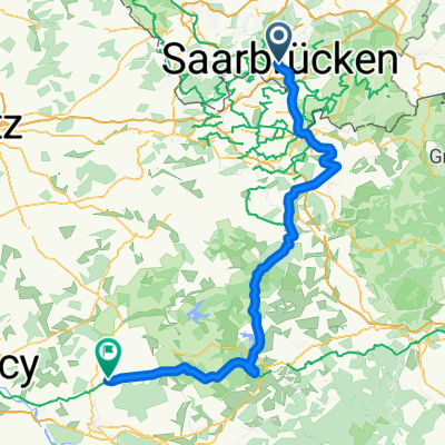 Saarbrücken - Einville-au-Jard
- Distance
- 120 km
- Ascent
- 452 m
- Descent
- 433 m
- Location
- Saarbrücken, Saarland, Germany
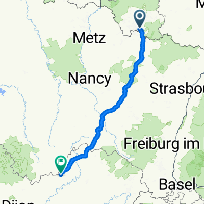 Saarbrücken - Bains-les-Bains
- Distance
- 251 km
- Ascent
- 2,396 m
- Descent
- 2,331 m
- Location
- Saarbrücken, Saarland, Germany
 Saarbrücken - Burgund - Loire - Guerande
- Distance
- 1,093.3 km
- Ascent
- 831 m
- Descent
- 995 m
- Location
- Saarbrücken, Saarland, Germany
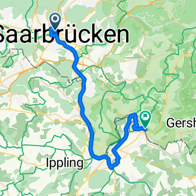 1. Etappe Camping Habkirchen
- Distance
- 33.7 km
- Ascent
- 266 m
- Descent
- 266 m
- Location
- Saarbrücken, Saarland, Germany
 Bike&Boulder
- Distance
- 29.2 km
- Ascent
- 381 m
- Descent
- 381 m
- Location
- Saarbrücken, Saarland, Germany
 Längere Feierabend Runde
- Distance
- 61 km
- Ascent
- 540 m
- Descent
- 535 m
- Location
- Saarbrücken, Saarland, Germany
Open it in the app