

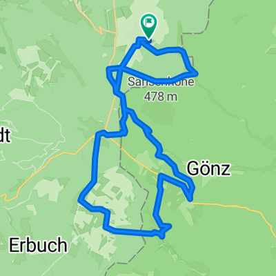
Vielbrunn - Würzberg - Hesselbach - Kastell Zwing - Schloß Waldleiningen - Breitenbach - Dörnbach - Breitenbuch - Watterbach - Boxbrunn - Eulbach
A cycling route starting in Rüdenau, Bavaria, Germany.
Overview
About this route
offen
- -:--
- Duration
- 54.7 km
- Distance
- 514 m
- Ascent
- 514 m
- Descent
- ---
- Avg. speed
- ---
- Max. altitude

Route quality
Waytypes & surfaces along the route
Waytypes
Quiet road
16.4 km
(30 %)
Road
12.6 km
(23 %)
Surfaces
Paved
36.1 km
(66 %)
Unpaved
2.2 km
(4 %)
Asphalt
26.8 km
(49 %)
Paved (undefined)
9.3 km
(17 %)
Continue with Bikemap
Use, edit, or download this cycling route
You would like to ride Vielbrunn - Würzberg - Hesselbach - Kastell Zwing - Schloß Waldleiningen - Breitenbach - Dörnbach - Breitenbuch - Watterbach - Boxbrunn - Eulbach or customize it for your own trip? Here is what you can do with this Bikemap route:
Free features
- Save this route as favorite or in collections
- Copy & plan your own version of this route
- Sync your route with Garmin or Wahoo
Premium features
Free trial for 3 days, or one-time payment. More about Bikemap Premium.
- Navigate this route on iOS & Android
- Export a GPX / KML file of this route
- Create your custom printout (try it for free)
- Download this route for offline navigation
Discover more Premium features.
Get Bikemap PremiumFrom our community
Other popular routes starting in Rüdenau
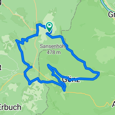 Vielbrunn - Gönz - Boxbrunn - Mangelsbach - Eulbach - Weiten-Gesäß
- Distance
- 35.9 km
- Ascent
- 841 m
- Descent
- 841 m
- Location
- Rüdenau, Bavaria, Germany
 Vielbrunn - Windlücke - Rimhorn - Höchst - Bad König - Momart - Kimbach
- Distance
- 33 km
- Ascent
- 473 m
- Descent
- 473 m
- Location
- Rüdenau, Bavaria, Germany
 Vielbrunn - Eberbach
- Distance
- 75 km
- Ascent
- 483 m
- Descent
- 779 m
- Location
- Rüdenau, Bavaria, Germany
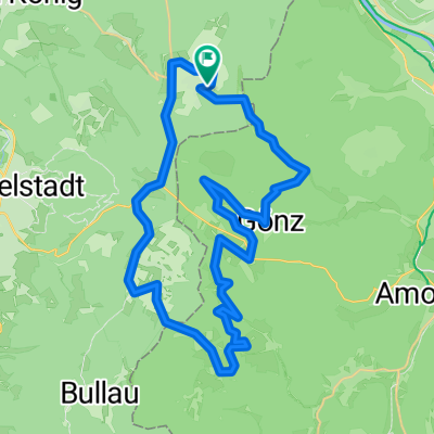 Vielbrunn - Gönz - Leidensweg - Boxbrunn - Eselspfad - Watterbach - Breitenbuch - Würzberg
- Distance
- 43.3 km
- Ascent
- 1,007 m
- Descent
- 1,011 m
- Location
- Rüdenau, Bavaria, Germany
 Vielbrunn - Amorbach - Kirchzell - Franziscus Weg (Talgrabenweg) - Boxbrunn - Eulbach - Müller Weg - Weiten-Gesäß
- Distance
- 42.8 km
- Ascent
- 513 m
- Descent
- 516 m
- Location
- Rüdenau, Bavaria, Germany
 Vielbrunn - Amorbach - Beuchen - Amorbach - Ohrnbach - Vielbrunn
- Distance
- 54.1 km
- Ascent
- 1,055 m
- Descent
- 1,056 m
- Location
- Rüdenau, Bavaria, Germany
 Vielbrunn - Amorbach - Ernsttal - Schlossau - Limesweg - Hesselbach - Würzberg
- Distance
- 62.6 km
- Ascent
- 1,083 m
- Descent
- 1,071 m
- Location
- Rüdenau, Bavaria, Germany
 Vielbrunn - Walbertstal - Gönzbachtal - Leidensweg - Boxbrunn - Eselspfad - Hainstermühle - Würzberg - Vielbrunn
- Distance
- 31.3 km
- Ascent
- 813 m
- Descent
- 815 m
- Location
- Rüdenau, Bavaria, Germany
Open it in the app