balade par le col des brosses
A cycling route starting in Noir茅table, Auvergne-Rh么ne-Alpes, France.
Overview
About this route
septembre 2012
samedi blind light- -:--
- Duration
- 113.4 km
- Distance
- 1,232 m
- Ascent
- 1,429 m
- Descent
- ---
- Avg. speed
- ---
- Avg. speed
Route quality
Waytypes & surfaces along the route
Waytypes
Road
55.2 km
(49 %)
Busy road
42.8 km
(38 %)
Surfaces
Paved
17.8 km
(16 %)
Unpaved
0.3 km
(<1 %)
Asphalt
17.8 km
(16 %)
Ground
0.3 km
(<1 %)
Undefined
95.3 km
(84 %)
Continue with Bikemap
Use, edit, or download this cycling route
You would like to ride balade par le col des brosses or customize it for your own trip? Here is what you can do with this Bikemap route:
Free features
- Save this route as favorite or in collections
- Copy & plan your own version of this route
- Sync your route with Garmin or Wahoo
Premium features
Free trial for 3 days, or one-time payment. More about Bikemap Premium.
- Navigate this route on iOS & Android
- Export a GPX / KML file of this route
- Create your custom printout (try it for free)
- Download this route for offline navigation
Discover more Premium features.
Get Bikemap PremiumFrom our community
Other popular routes starting in Noir茅table
- 12 Route de Gontey, Cervi猫res to 6 Place Jean Charbonnel, Brive-la-Gaillarde
- Distance
- 240.9 km
- Ascent
- 3,405 m
- Descent
- 4,073 m
- Location
- Noir茅table, Auvergne-Rh么ne-Alpes, France
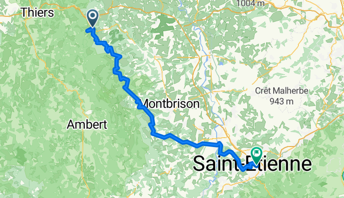
- GR3-en haut-les Pradeaux
- Distance
- 71.7 km
- Ascent
- 705 m
- Descent
- 619 m
- Location
- Noir茅table, Auvergne-Rh么ne-Alpes, France
- balade par le col des brosses
- Distance
- 113.4 km
- Ascent
- 1,232 m
- Descent
- 1,429 m
- Location
- Noir茅table, Auvergne-Rh么ne-Alpes, France
- D0620 Noiretable - Le Clemencon
- Distance
- 67.3 km
- Ascent
- 532 m
- Descent
- 768 m
- Location
- Noir茅table, Auvergne-Rh么ne-Alpes, France
- PIERRE DES MORTS, por La Chambonie
- Distance
- 4.6 km
- Ascent
- 247 m
- Descent
- 60 m
- Location
- Noir茅table, Auvergne-Rh么ne-Alpes, France
- Forez
- Distance
- 72.1 km
- Ascent
- 1,216 m
- Descent
- 1,215 m
- Location
- Noir茅table, Auvergne-Rh么ne-Alpes, France
- La Goutte - Col de Biel - St. Pierre - Marat - Les Mines
- Distance
- 48.3 km
- Ascent
- 1,010 m
- Descent
- 1,047 m
- Location
- Noir茅table, Auvergne-Rh么ne-Alpes, France
- thiers
- Distance
- 25.6 km
- Ascent
- 495 m
- Descent
- 739 m
- Location
- Noir茅table, Auvergne-Rh么ne-Alpes, France
Open it in the app