

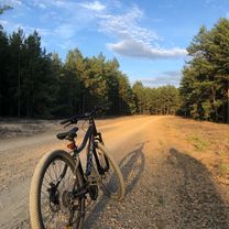
BSOrient - II miejsce w GIGA
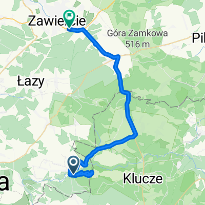
A cycling route starting in Łazy Bledowskie, Silesian Voivodeship, Poland.
Overview
About this route
- -:--
- Duration
- 105 km
- Distance
- 609 m
- Ascent
- 607 m
- Descent
- ---
- Avg. speed
- ---
- Max. altitude
Route quality
Waytypes & surfaces along the route
Waytypes
Road
27.3 km
(26 %)
Quiet road
24.1 km
(23 %)
Surfaces
Paved
61.9 km
(59 %)
Unpaved
18.9 km
(18 %)
Asphalt
61.9 km
(59 %)
Unpaved (undefined)
5.2 km
(5 %)
Route highlights
Points of interest along the route
Point of interest after 0 km
PK 9 - Mostek Anik - zdejmujemy buty
Point of interest after 3.5 km
PK 5 - Kryjówka Wudza
Point of interest after 7.5 km
PK 8 - Wielbłąd Mariatrucka
Point of interest after 8.7 km
Tablica informacyjna przy Pustynii Mavika
Point of interest after 16.5 km
PK 15 -Powalone drzewo przy mostku Oli
Point of interest after 18.1 km
Wieża widokowa a'la żyrafa Morsa
Point of interest after 29.5 km
PK 17 Mostek Glebożercy
Point of interest after 30.5 km
PK 21 - Ruiny zamku Asiczki
Point of interest after 34.4 km
PK 19 - Pomnik Niewe'go
Point of interest after 41.6 km
PK 20 - Pniak wewnątrz ruin zamku CheEvary
Point of interest after 45.3 km
PK 18 - Przy świętym obrazie Agenciary
Point of interest after 56.1 km
PK 12 - Latarnia od północnej strony zamku Amigi
Point of interest after 58.7 km
PK 16 - skrzyżowanie ścieżek Niradhary i Kajmana
Point of interest after 64.4 km
PK 13 - skrzyżowanie szlaków Edytki i Tadzika1963
Point of interest after 70.4 km
PK 11 - Skrzyżowanie ścieżek AniBani i Jurka
Point of interest after 77.1 km
PK 10 - Skałki Tomalosa
Point of interest after 83.5 km
PK 7 - Pomnik Utatu i Arta75
Point of interest after 92.4 km
PK 3 - Skrzyżowanie dróg imienia Igorka i Wiktorii
Point of interest after 94.9 km
PK 1 - Okolice młyna Młynarza - na drzewie
Point of interest after 97.7 km
PK 2 - Skrzyżowanie ścieżek imienia Dejotka i Anetki
Point of interest after 100.7 km
PK 6 - Kapliczka pod wezwaniem Boskiego Blase'a
Continue with Bikemap
Use, edit, or download this cycling route
You would like to ride BSOrient - II miejsce w GIGA or customize it for your own trip? Here is what you can do with this Bikemap route:
Free features
- Save this route as favorite or in collections
- Copy & plan your own version of this route
- Split it into stages to create a multi-day tour
- Sync your route with Garmin or Wahoo
Premium features
Free trial for 3 days, or one-time payment. More about Bikemap Premium.
- Navigate this route on iOS & Android
- Export a GPX / KML file of this route
- Create your custom printout (try it for free)
- Download this route for offline navigation
Discover more Premium features.
Get Bikemap PremiumFrom our community
Other popular routes starting in Łazy Bledowskie
 2014.04.21 Lany Poniedziałek z widokiem na Góry Świętokrzyskie
- Distance
- 187.5 km
- Ascent
- 561 m
- Descent
- 559 m
- Location
- Łazy Bledowskie, Silesian Voivodeship, Poland
 2014.04.21 Lany Poniedziałek z widokiem na Góry Świętokrzyskie
- Distance
- 189.6 km
- Ascent
- 515 m
- Descent
- 515 m
- Location
- Łazy Bledowskie, Silesian Voivodeship, Poland
 Jesionowa 1A, Dąbrowa Górnicza do Kozłowska 1, Sławków
- Distance
- 10.2 km
- Ascent
- 86 m
- Descent
- 79 m
- Location
- Łazy Bledowskie, Silesian Voivodeship, Poland
 pustynia błędowska
- Distance
- 10.6 km
- Ascent
- 344 m
- Descent
- 330 m
- Location
- Łazy Bledowskie, Silesian Voivodeship, Poland
 trasa treningowa szybka
- Distance
- 51.4 km
- Ascent
- 280 m
- Descent
- 261 m
- Location
- Łazy Bledowskie, Silesian Voivodeship, Poland
 Bike Atelier MTB Maraton 2016 - Dąbrowa Górnicza - PRO
- Distance
- 65.1 km
- Ascent
- 408 m
- Descent
- 408 m
- Location
- Łazy Bledowskie, Silesian Voivodeship, Poland
 Bike Atelier MTB Maraton 2016 - Dąbrowa Górnicza - HOBBY
- Distance
- 23.2 km
- Ascent
- 157 m
- Descent
- 154 m
- Location
- Łazy Bledowskie, Silesian Voivodeship, Poland
 Dąbrowa Górnicza do Lipowa, Zawiercie
- Distance
- 31.8 km
- Ascent
- 330 m
- Descent
- 295 m
- Location
- Łazy Bledowskie, Silesian Voivodeship, Poland
Open it in the app