

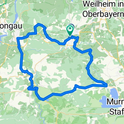
Pbg.-Uffing-Bad Kohlgrub-Pbg
A cycling route starting in Peißenberg, Bavaria, Germany.
Overview
About this route
MTB Tour. With short difficult sections, otherwise passable with a bit of fitness. The start is at the Ammerbrücke Wörth, on the left side of the Ammer. Unfortunately, I had to ride along the federal road from Roßlaich to Huglfing due to the railway construction.
- -:--
- Duration
- 58 km
- Distance
- 396 m
- Ascent
- 394 m
- Descent
- ---
- Avg. speed
- ---
- Max. altitude

Continue with Bikemap
Use, edit, or download this cycling route
You would like to ride Pbg.-Uffing-Bad Kohlgrub-Pbg or customize it for your own trip? Here is what you can do with this Bikemap route:
Free features
- Save this route as favorite or in collections
- Copy & plan your own version of this route
- Sync your route with Garmin or Wahoo
Premium features
Free trial for 3 days, or one-time payment. More about Bikemap Premium.
- Navigate this route on iOS & Android
- Export a GPX / KML file of this route
- Create your custom printout (try it for free)
- Download this route for offline navigation
Discover more Premium features.
Get Bikemap PremiumFrom our community
Other popular routes starting in Peißenberg
 jakob giessrunde
- Distance
- 6.7 km
- Ascent
- 8 m
- Descent
- 8 m
- Location
- Peißenberg, Bavaria, Germany
 Wörther Straße 12A, Peißenberg nach Wörther Straße 12A, Peißenberg
- Distance
- 28.2 km
- Ascent
- 430 m
- Descent
- 413 m
- Location
- Peißenberg, Bavaria, Germany
 Peißenberg-Schöffau
- Distance
- 63.1 km
- Ascent
- 916 m
- Descent
- 913 m
- Location
- Peißenberg, Bavaria, Germany
 Rund um den Hohen Peissenberg
- Distance
- 30.1 km
- Ascent
- 426 m
- Descent
- 428 m
- Location
- Peißenberg, Bavaria, Germany
 Mtb Runde von Peißenberg, Carl-Benz-Straße, über Ammerhöfe, runter zur Ammer und zurück
- Distance
- 18.3 km
- Ascent
- 261 m
- Descent
- 265 m
- Location
- Peißenberg, Bavaria, Germany
 Peißenberg-Bad Bayersoien
- Distance
- 65.7 km
- Ascent
- 959 m
- Descent
- 954 m
- Location
- Peißenberg, Bavaria, Germany
 WM15 15, Peißenberg nach Wörther Straße 12A, Peißenberg
- Distance
- 17.1 km
- Ascent
- 219 m
- Descent
- 197 m
- Location
- Peißenberg, Bavaria, Germany
 Grubsee
- Distance
- 47 km
- Ascent
- 548 m
- Descent
- 545 m
- Location
- Peißenberg, Bavaria, Germany
Open it in the app