

Tour de Hügel No.1
A cycling route starting in Gau-Algesheim, Rhineland-Palatinate, Germany.
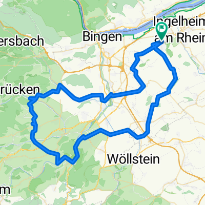
Overview
About this route
Route:
Uphills and downhills from Windesheim, Wallhausen, Sommerloch, St. Katharinen, Mandel, Weinsheim, Hüffelsheim via Norheim to Bad Kreuznach, Sprendlingen via the Col de Müll back to Gau-Algesheim.
Dream ride with dream views over the Rheinhessen plateau and hills.
- -:--
- Duration
- 80.6 km
- Distance
- 667 m
- Ascent
- 670 m
- Descent
- ---
- Avg. speed
- ---
- Max. altitude

Route quality
Waytypes & surfaces along the route
Waytypes
Road
20.2 km
(25 %)
Track
11.3 km
(14 %)
Surfaces
Paved
61.3 km
(76 %)
Unpaved
1.6 km
(2 %)
Asphalt
57.2 km
(71 %)
Paved (undefined)
3.2 km
(4 %)
Route highlights
Points of interest along the route
Point of interest after 35.2 km
Traumhafter Rundum-Blick
Continue with Bikemap
Use, edit, or download this cycling route
You would like to ride Tour de Hügel No.1 or customize it for your own trip? Here is what you can do with this Bikemap route:
Free features
- Save this route as favorite or in collections
- Copy & plan your own version of this route
- Split it into stages to create a multi-day tour
- Sync your route with Garmin or Wahoo
Premium features
Free trial for 3 days, or one-time payment. More about Bikemap Premium.
- Navigate this route on iOS & Android
- Export a GPX / KML file of this route
- Create your custom printout (try it for free)
- Download this route for offline navigation
Discover more Premium features.
Get Bikemap PremiumFrom our community
Other popular routes starting in Gau-Algesheim
 029b
029b- Distance
- 49.8 km
- Ascent
- 370 m
- Descent
- 368 m
- Location
- Gau-Algesheim, Rhineland-Palatinate, Germany
 Tour de Hügel No.1
- Distance
- 80.6 km
- Ascent
- 667 m
- Descent
- 670 m
- Location
- Gau-Algesheim, Rhineland-Palatinate, Germany
 009c Ingelheim - Daxweiler - Stromberg - Horrweiler - Ingelheim
- Distance
- 66.1 km
- Ascent
- 659 m
- Descent
- 643 m
- Location
- Gau-Algesheim, Rhineland-Palatinate, Germany
 006b Ingelheim - Sprendlingen - Wolfsheim - Saulheim - Ingelheim
- Distance
- 55.4 km
- Ascent
- 510 m
- Descent
- 489 m
- Location
- Gau-Algesheim, Rhineland-Palatinate, Germany
 006c Ingelheim - Wörrstadt - Saulheim - Ingelheim
- Distance
- 46.9 km
- Ascent
- 339 m
- Descent
- 319 m
- Location
- Gau-Algesheim, Rhineland-Palatinate, Germany
 011c Ingelheim - Pfaffen-Schwabenheim - Vendersheim - Ingelheim
- Distance
- 57.5 km
- Ascent
- 529 m
- Descent
- 511 m
- Location
- Gau-Algesheim, Rhineland-Palatinate, Germany
 003a Ingelheim - Lauschhütte - Dörrebach - Ingelheim
- Distance
- 67.7 km
- Ascent
- 762 m
- Descent
- 763 m
- Location
- Gau-Algesheim, Rhineland-Palatinate, Germany
 001a Ingelheim - Rümmelsheim - Daxweiler - Ingelheim
- Distance
- 67.2 km
- Ascent
- 784 m
- Descent
- 778 m
- Location
- Gau-Algesheim, Rhineland-Palatinate, Germany
Open it in the app