

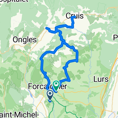
Bng_Mane25k
A cycling route starting in Mane, Provence-Alpes-Côte d'Azur Region, France.
Overview
About this route
- -:--
- Duration
- 24.6 km
- Distance
- 306 m
- Ascent
- 307 m
- Descent
- ---
- Avg. speed
- ---
- Max. altitude

Route quality
Waytypes & surfaces along the route
Waytypes
Road
13.3 km
(54 %)
Quiet road
9.6 km
(39 %)
Undefined
1.7 km
(7 %)
Surfaces
Paved
13.5 km
(55 %)
Unpaved
0.5 km
(2 %)
Asphalt
13.5 km
(55 %)
Ground
0.5 km
(2 %)
Undefined
10.6 km
(43 %)
Continue with Bikemap
Use, edit, or download this cycling route
You would like to ride Bng_Mane25k or customize it for your own trip? Here is what you can do with this Bikemap route:
Free features
- Save this route as favorite or in collections
- Copy & plan your own version of this route
- Sync your route with Garmin or Wahoo
Premium features
Free trial for 3 days, or one-time payment. More about Bikemap Premium.
- Navigate this route on iOS & Android
- Export a GPX / KML file of this route
- Create your custom printout (try it for free)
- Download this route for offline navigation
Discover more Premium features.
Get Bikemap PremiumFrom our community
Other popular routes starting in Mane
 Tappa 5 FaunTour2k22
- Distance
- 101.9 km
- Ascent
- 466 m
- Descent
- 851 m
- Location
- Mane, Provence-Alpes-Côte d'Azur Region, France
 Forcalquier est
- Distance
- 54.1 km
- Ascent
- 660 m
- Descent
- 660 m
- Location
- Mane, Provence-Alpes-Côte d'Azur Region, France
 Etapa 088B (Dauphin - Arlés)
- Distance
- 153.3 km
- Ascent
- 786 m
- Descent
- 1,173 m
- Location
- Mane, Provence-Alpes-Côte d'Azur Region, France
 villeneuve
- Distance
- 55.7 km
- Ascent
- 630 m
- Descent
- 638 m
- Location
- Mane, Provence-Alpes-Côte d'Azur Region, France
 etape 2
- Distance
- 57.4 km
- Ascent
- 425 m
- Descent
- 519 m
- Location
- Mane, Provence-Alpes-Côte d'Azur Region, France
 Chemin St Suffren, Forcalquier à Route de la Brillanne, Forcalquier
- Distance
- 53.2 km
- Ascent
- 1,438 m
- Descent
- 1,428 m
- Location
- Mane, Provence-Alpes-Côte d'Azur Region, France
 Bng_Mane25k
- Distance
- 24.6 km
- Ascent
- 306 m
- Descent
- 307 m
- Location
- Mane, Provence-Alpes-Côte d'Azur Region, France
 D3Nyons 100
- Distance
- 116.1 km
- Ascent
- 1,102 m
- Descent
- 1,254 m
- Location
- Mane, Provence-Alpes-Côte d'Azur Region, France
Open it in the app