
Rundtour "Cadolzburg"
A cycling route starting in Dietenhofen, Bavaria, Germany.
Overview
About this route
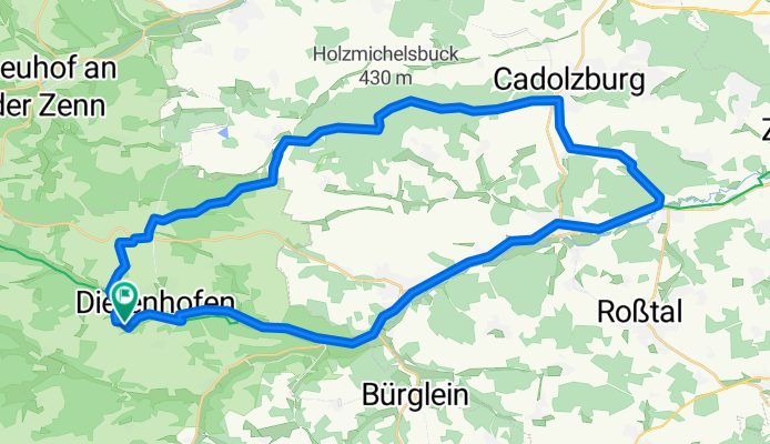
Beautiful trekking bike tour from Dietenhofen through long forest stretches to Cadolzburg, then over Steinbach through the forest to Wienzierlein and back to Dietenhofen via the Biberttal cycle path.
Ideal for trekking bike.
Only at the beginning in Dietenhofen is there a steeper section, then only gentle climbs to Cadolzburg.
- -:--
- Duration
- 41.7 km
- Distance
- 257 m
- Ascent
- 257 m
- Descent
- ---
- Avg. speed
- ---
- Max. altitude

Route quality
Waytypes & surfaces along the route
Waytypes
Track
21.3 km
(51 %)
Quiet road
7.9 km
(19 %)
Surfaces
Paved
22.1 km
(53 %)
Unpaved
13.3 km
(32 %)
Asphalt
21.7 km
(52 %)
Loose gravel
7.9 km
(19 %)
Continue with Bikemap
Use, edit, or download this cycling route
You would like to ride Rundtour "Cadolzburg" or customize it for your own trip? Here is what you can do with this Bikemap route:
Free features
- Save this route as favorite or in collections
- Copy & plan your own version of this route
- Sync your route with Garmin or Wahoo
Premium features
Free trial for 3 days, or one-time payment. More about Bikemap Premium.
- Navigate this route on iOS & Android
- Export a GPX / KML file of this route
- Create your custom printout (try it for free)
- Download this route for offline navigation
Discover more Premium features.
Get Bikemap PremiumFrom our community
Other popular routes starting in Dietenhofen
 Rundtour "Saisonabschluß"
- Distance
- 26.6 km
- Ascent
- 220 m
- Descent
- 220 m
- Location
- Dietenhofen, Bavaria, Germany
 3-Tagestour 2013 "Kneippradweg"
- Distance
- 175.8 km
- Ascent
- 655 m
- Descent
- 655 m
- Location
- Dietenhofen, Bavaria, Germany
 Rundtour "Trautskirchen/Merzbach/Neuhof"
- Distance
- 35.2 km
- Ascent
- 362 m
- Descent
- 362 m
- Location
- Dietenhofen, Bavaria, Germany
 Rundtour "Mettlachtal"
- Distance
- 25.2 km
- Ascent
- 271 m
- Descent
- 271 m
- Location
- Dietenhofen, Bavaria, Germany
 Rundtour "Cadolzburg"
- Distance
- 41.7 km
- Ascent
- 257 m
- Descent
- 257 m
- Location
- Dietenhofen, Bavaria, Germany
 Kinder-Tour "Bolzplatz"
- Distance
- 11.6 km
- Ascent
- 161 m
- Descent
- 161 m
- Location
- Dietenhofen, Bavaria, Germany
 Rundtour "Bibert-Tal"
- Distance
- 29.2 km
- Ascent
- 207 m
- Descent
- 207 m
- Location
- Dietenhofen, Bavaria, Germany
 Rundtour "Sonnensee"
- Distance
- 46.5 km
- Ascent
- 282 m
- Descent
- 285 m
- Location
- Dietenhofen, Bavaria, Germany
Open it in the app