

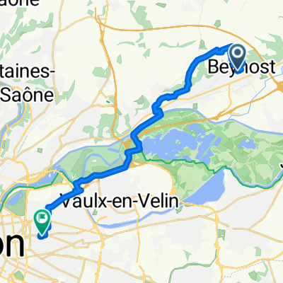
2012 French Tour -- Ride Day 33 -- 18 September 2012 -- Beynost (Lyon) to Thézillieu
A cycling route starting in Beynost, Auvergne-Rhône-Alpes, France.
Overview
About this route
To be added later...
With the exceptions of D65B, D1084, D904, and D1504, all roads were very good low-traffic roads with nice countryside. These four, however, weren't so bad as the traffic was relatively light and there was often shoulder to ride on. The first portion of the ride was very flat. The second second portion was a good climb to the Plateau d'Hauteville. <div><br /></div>
- -:--
- Duration
- 83.8 km
- Distance
- 718 m
- Ascent
- 33 m
- Descent
- ---
- Avg. speed
- ---
- Max. altitude

Route quality
Waytypes & surfaces along the route
Waytypes
Busy road
58.1 km
(69 %)
Road
12.4 km
(15 %)
Surfaces
Paved
43.3 km
(52 %)
Unpaved
0.2 km
(<1 %)
Asphalt
43.3 km
(52 %)
Unpaved (undefined)
0.2 km
(<1 %)
Undefined
40.3 km
(48 %)
Continue with Bikemap
Use, edit, or download this cycling route
You would like to ride 2012 French Tour -- Ride Day 33 -- 18 September 2012 -- Beynost (Lyon) to Thézillieu or customize it for your own trip? Here is what you can do with this Bikemap route:
Free features
- Save this route as favorite or in collections
- Copy & plan your own version of this route
- Split it into stages to create a multi-day tour
- Sync your route with Garmin or Wahoo
Premium features
Free trial for 3 days, or one-time payment. More about Bikemap Premium.
- Navigate this route on iOS & Android
- Export a GPX / KML file of this route
- Create your custom printout (try it for free)
- Download this route for offline navigation
Discover more Premium features.
Get Bikemap PremiumFrom our community
Other popular routes starting in Beynost
 Rue Centrale 423, Beynost to Unnamed Road, Villars-les-Dombes
- Distance
- 23.5 km
- Ascent
- 151 m
- Descent
- 154 m
- Location
- Beynost, Auvergne-Rhône-Alpes, France
 2012 French Tour -- Ride Day 33 -- 18 September 2012 -- Beynost (Lyon) to Thézillieu
- Distance
- 83.8 km
- Ascent
- 718 m
- Descent
- 33 m
- Location
- Beynost, Auvergne-Rhône-Alpes, France
 De Chemin du Mont 309, Beynost à Montee de la Demi-Lune 245, Beynost
- Distance
- 5.1 km
- Ascent
- 118 m
- Descent
- 199 m
- Location
- Beynost, Auvergne-Rhône-Alpes, France
 Itinéraire vers 10–22 Rue Romy schneider, Saint-Priest
- Distance
- 26.3 km
- Ascent
- 135 m
- Descent
- 121 m
- Location
- Beynost, Auvergne-Rhône-Alpes, France
 De Impasse des Érables 145, Beynost à Impasse des Érables 145, Beynost
- Distance
- 18.1 km
- Ascent
- 96 m
- Descent
- 98 m
- Location
- Beynost, Auvergne-Rhône-Alpes, France
 De Impasse des Érables 145, Beynost à Rue des Folliets 6, Saint-Maurice-de-Beynost
- Distance
- 2.5 km
- Ascent
- 16 m
- Descent
- 10 m
- Location
- Beynost, Auvergne-Rhône-Alpes, France
 De 6330 Chemin de Pré Mayeux, Beynost à 1452B Rue Centrale, Beynost
- Distance
- 2.4 km
- Ascent
- 27 m
- Descent
- 12 m
- Location
- Beynost, Auvergne-Rhône-Alpes, France
 De Rue Centrale 572, Beynost à Rue Saint-Antoine 50, Lyon
- Distance
- 22.1 km
- Ascent
- 253 m
- Descent
- 283 m
- Location
- Beynost, Auvergne-Rhône-Alpes, France
Open it in the app