

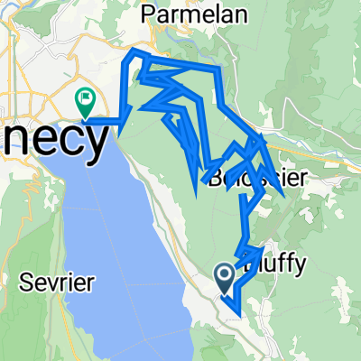
tour du mt veyrier
A cycling route starting in Menthon-Saint-Bernard, Auvergne-Rhône-Alpes, France.
Overview
About this route
mainly single track. Some carry sections.
- -:--
- Duration
- 22.5 km
- Distance
- 854 m
- Ascent
- 852 m
- Descent
- ---
- Avg. speed
- ---
- Max. altitude
Continue with Bikemap
Use, edit, or download this cycling route
You would like to ride tour du mt veyrier or customize it for your own trip? Here is what you can do with this Bikemap route:
Free features
- Save this route as favorite or in collections
- Copy & plan your own version of this route
- Sync your route with Garmin or Wahoo
Premium features
Free trial for 3 days, or one-time payment. More about Bikemap Premium.
- Navigate this route on iOS & Android
- Export a GPX / KML file of this route
- Create your custom printout (try it for free)
- Download this route for offline navigation
Discover more Premium features.
Get Bikemap PremiumFrom our community
Other popular routes starting in Menthon-Saint-Bernard
 titre
titre- Distance
- 65.5 km
- Ascent
- 3,893 m
- Descent
- 3,939 m
- Location
- Menthon-Saint-Bernard, Auvergne-Rhône-Alpes, France
 lac de annecy
- Distance
- 73 km
- Ascent
- 1,484 m
- Descent
- 1,484 m
- Location
- Menthon-Saint-Bernard, Auvergne-Rhône-Alpes, France
 Tour du Lac...
- Distance
- 37.4 km
- Ascent
- 223 m
- Descent
- 225 m
- Location
- Menthon-Saint-Bernard, Auvergne-Rhône-Alpes, France
 Abschlußtour
- Distance
- 127.3 km
- Ascent
- 2,133 m
- Descent
- 2,133 m
- Location
- Menthon-Saint-Bernard, Auvergne-Rhône-Alpes, France
 Menthon Saint Bernard - Col de la Colombiére
- Distance
- 42.3 km
- Ascent
- 1,440 m
- Descent
- 747 m
- Location
- Menthon-Saint-Bernard, Auvergne-Rhône-Alpes, France
 Col de la Croix Fry - Col de la Forclaz
- Distance
- 83 km
- Ascent
- 1,784 m
- Descent
- 1,784 m
- Location
- Menthon-Saint-Bernard, Auvergne-Rhône-Alpes, France
 JH Menthon Round Trip Via Thones
- Distance
- 50 km
- Ascent
- 625 m
- Descent
- 620 m
- Location
- Menthon-Saint-Bernard, Auvergne-Rhône-Alpes, France
 tour du mt veyrier
- Distance
- 22.5 km
- Ascent
- 854 m
- Descent
- 852 m
- Location
- Menthon-Saint-Bernard, Auvergne-Rhône-Alpes, France
Open it in the app