

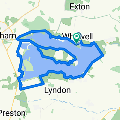
Scotty Ash scenic route.
A cycling route starting in Empingham, England, United Kingdom.
Overview
About this route
A gentle route from the north or south Carpark / bikehire, use the lakeside path to start and finish, if you are starting from the north car park use the path as its steadier to start for those not used to the bikes, nice flat roads to start with to get used to the bikes then a few slopes around Braunston / knossington then the pretty vilage of Lyndon. if you enter the south car park at Normanton and follow the riverside path, they have giant Zorbs on the dam wall which you can pay to go in. Good luck, will come if I can ! M.
- -:--
- Duration
- 43.3 km
- Distance
- 277 m
- Ascent
- 276 m
- Descent
- ---
- Avg. speed
- ---
- Max. altitude
Route quality
Waytypes & surfaces along the route
Waytypes
Quiet road
28.5 km
(66 %)
Road
9.9 km
(23 %)
Surfaces
Paved
8.7 km
(20 %)
Asphalt
8.7 km
(20 %)
Undefined
34.6 km
(80 %)
Continue with Bikemap
Use, edit, or download this cycling route
You would like to ride Scotty Ash scenic route. or customize it for your own trip? Here is what you can do with this Bikemap route:
Free features
- Save this route as favorite or in collections
- Copy & plan your own version of this route
- Sync your route with Garmin or Wahoo
Premium features
Free trial for 3 days, or one-time payment. More about Bikemap Premium.
- Navigate this route on iOS & Android
- Export a GPX / KML file of this route
- Create your custom printout (try it for free)
- Download this route for offline navigation
Discover more Premium features.
Get Bikemap PremiumFrom our community
Other popular routes starting in Empingham
 rutland west
- Distance
- 34.9 km
- Ascent
- 351 m
- Descent
- 351 m
- Location
- Empingham, England, United Kingdom
 Vitruvian Bike Course
- Distance
- 41.4 km
- Ascent
- 318 m
- Descent
- 317 m
- Location
- Empingham, England, United Kingdom
 Route in Oakham
- Distance
- 37.1 km
- Ascent
- 242 m
- Descent
- 239 m
- Location
- Empingham, England, United Kingdom
 Whitwell 10 Miler
- Distance
- 27.6 km
- Ascent
- 162 m
- Descent
- 161 m
- Location
- Empingham, England, United Kingdom
 Rutland
- Distance
- 24.4 km
- Ascent
- 119 m
- Descent
- 119 m
- Location
- Empingham, England, United Kingdom
 Scotty Ash scenic route.
- Distance
- 43.3 km
- Ascent
- 277 m
- Descent
- 276 m
- Location
- Empingham, England, United Kingdom
 Recovered Route
- Distance
- 9 km
- Ascent
- 66 m
- Descent
- 68 m
- Location
- Empingham, England, United Kingdom
 Bull Brig Lane 2, Whitwell to Bull Brig Lane 2, Whitwell
- Distance
- 35 km
- Ascent
- 119 m
- Descent
- 119 m
- Location
- Empingham, England, United Kingdom
Open it in the app