
Trimm Dich Tour
A cycling route starting in Weitramsdorf, Bavaria, Germany.
Overview
About this route
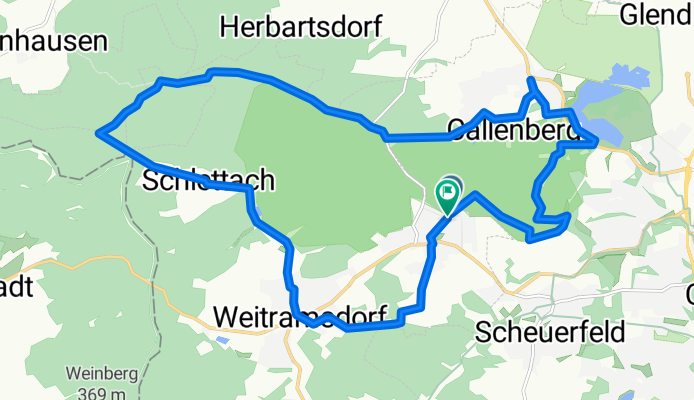
Get Fit: A combined tour along the marked Trimm Dich path followed by a short mountain hike through Callenberg Forest: this is how you can quickly get in shape!
- -:--
- Duration
- 21 km
- Distance
- 255 m
- Ascent
- 314 m
- Descent
- ---
- Avg. speed
- 407 m
- Max. altitude

Route quality
Waytypes & surfaces along the route
Waytypes
Track
9.7 km
(46 %)
Quiet road
8.8 km
(42 %)
Surfaces
Paved
5.5 km
(26 %)
Unpaved
9.2 km
(44 %)
Gravel
6.5 km
(31 %)
Asphalt
3.6 km
(17 %)
Route highlights
Points of interest along the route

Point of interest after 0 km
Wasserturm in Weidach

Point of interest after 2 km
Ernstfarm

Point of interest after 6.2 km
Schloss Callenberg
Continue with Bikemap
Use, edit, or download this cycling route
You would like to ride Trimm Dich Tour or customize it for your own trip? Here is what you can do with this Bikemap route:
Free features
- Save this route as favorite or in collections
- Copy & plan your own version of this route
- Sync your route with Garmin or Wahoo
Premium features
Free trial for 3 days, or one-time payment. More about Bikemap Premium.
- Navigate this route on iOS & Android
- Export a GPX / KML file of this route
- Create your custom printout (try it for free)
- Download this route for offline navigation
Discover more Premium features.
Get Bikemap PremiumFrom our community
Other popular routes starting in Weitramsdorf
 2018-10-07: Bad Colberg - Bad Rodach - Coburg
- Distance
- 74.4 km
- Ascent
- 558 m
- Descent
- 558 m
- Location
- Weitramsdorf, Bavaria, Germany
 Parkallee 3, Heldburg nach Burgstraße 1, Heldburg
- Distance
- 13.2 km
- Ascent
- 197 m
- Descent
- 127 m
- Location
- Weitramsdorf, Bavaria, Germany
 Green Belt - Stage 7
- Distance
- 79.8 km
- Ascent
- 642 m
- Descent
- 545 m
- Location
- Weitramsdorf, Bavaria, Germany
 Runde Tambach - Rodach - Meeder - Scheuerfeld - Tambach
- Distance
- 47.3 km
- Ascent
- 352 m
- Descent
- 350 m
- Location
- Weitramsdorf, Bavaria, Germany
 Ummerstadt - Bad Colberg - Heldburg - Lindenau-Ummerstadt
- Distance
- 17 km
- Ascent
- 193 m
- Descent
- 193 m
- Location
- Weitramsdorf, Bavaria, Germany
 Strecke für den Konditionsaufbau
- Distance
- 17 km
- Ascent
- 77 m
- Descent
- 152 m
- Location
- Weitramsdorf, Bavaria, Germany
 2018-10-06: Bad Colberg - Seßlach - Bad Staffelstein
- Distance
- 83.6 km
- Ascent
- 647 m
- Descent
- 647 m
- Location
- Weitramsdorf, Bavaria, Germany
 Gleichberge
- Distance
- 80.1 km
- Ascent
- 886 m
- Descent
- 886 m
- Location
- Weitramsdorf, Bavaria, Germany
Open it in the app