

Hong Kong Island CLONED FROM ROUTE 123678
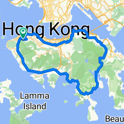
- 39.6 km
- 804 m
- 804 m
- Hong Kong, Central and Western District, Hong Kong
A cycling route starting in Hong Kong, Central and Western District, Hong Kong.
Overview
<span style="font-size: small;"><font color="#000000"><span lang="EN-US"><font face="Calibri">120921 </font></span><span style="font-family: "新細明體","serif"; mso-ascii-font-family: Calibri; mso-hansi-font-family: Calibri;">日到夜探港篤</span></font></span>
<span style="font-size: small;"><font color="#000000"><span style="font-family: "新細明體","serif"; mso-ascii-font-family: Calibri; mso-hansi-font-family: Calibri;">港島很多地方多數是過門而不入,今次能盡遊港島篤篤,小西灣、柴灣墳場、大浪、石澳山仔、鶴咀電台</span><span lang="EN-US"><font face="Calibri">(</font></span><span style="font-family: "新細明體","serif"; mso-ascii-font-family: Calibri; mso-hansi-font-family: Calibri;">低台、高台</span><span lang="EN-US"><font face="Calibri">) </font></span><span style="font-family: "新細明體","serif"; mso-ascii-font-family: Calibri; mso-hansi-font-family: Calibri;">、大潭篤、赤柱黃麻角、馬坑、樁磡角炮台,了結多年心願。</span></font></span>
<span style="font-family: "新細明體","serif"; mso-ascii-font-family: Calibri; mso-hansi-font-family: Calibri;"><span style="color: #000000; font-size: small;">還有魔鬼山及西環日落,要待十月再探。</span></span>
created this 13 years ago
Continue with Bikemap
You would like to ride 120921 日到夜探港篤 or customize it for your own trip? Here is what you can do with this Bikemap route:
Free trial for 3 days, or one-time payment. More about Bikemap Premium.
Discover more Premium features.
Get Bikemap PremiumFrom our community
Open it in the app


