

Höhenmeter im Fränkischen Jura
A cycling route starting in Lichtenfels, Bavaria, Germany.
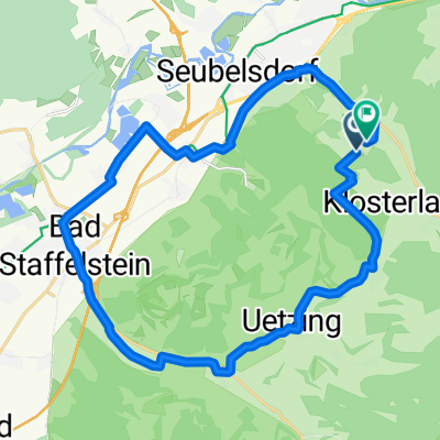
Overview
About this route
Road cycling route from the parking lot in Lichtenfels East with many (also steep) climbs and descents. Scenic beautiful valleys, sometimes narrow roads, quaint little villages, good dining options.
- -:--
- Duration
- 63.9 km
- Distance
- 1,018 m
- Ascent
- 1,017 m
- Descent
- ---
- Avg. speed
- ---
- Max. altitude
Route quality
Waytypes & surfaces along the route
Waytypes
Quiet road
26.2 km
(41 %)
Road
24.9 km
(39 %)
Surfaces
Paved
33.2 km
(52 %)
Unpaved
4.5 km
(7 %)
Asphalt
31.9 km
(50 %)
Gravel
2.6 km
(4 %)
Route highlights
Points of interest along the route
Point of interest after 0 km
Parkplatz
Continue with Bikemap
Use, edit, or download this cycling route
You would like to ride Höhenmeter im Fränkischen Jura or customize it for your own trip? Here is what you can do with this Bikemap route:
Free features
- Save this route as favorite or in collections
- Copy & plan your own version of this route
- Sync your route with Garmin or Wahoo
Premium features
Free trial for 3 days, or one-time payment. More about Bikemap Premium.
- Navigate this route on iOS & Android
- Export a GPX / KML file of this route
- Create your custom printout (try it for free)
- Download this route for offline navigation
Discover more Premium features.
Get Bikemap PremiumFrom our community
Other popular routes starting in Lichtenfels
 Lichtenfels - 2 Klöster (Staffelberg, 14 Hlg. , Banz) nach Coburg
- Distance
- 45.8 km
- Ascent
- 630 m
- Descent
- 602 m
- Location
- Lichtenfels, Bavaria, Germany
 Lichtenfels nach Bamberg
- Distance
- 38.3 km
- Ascent
- 35 m
- Descent
- 62 m
- Location
- Lichtenfels, Bavaria, Germany
 Kleiner Sonntagsausflug
- Distance
- 20.2 km
- Ascent
- 412 m
- Descent
- 408 m
- Location
- Lichtenfels, Bavaria, Germany
 Německo 2012-4.den-Main-Radweg
- Distance
- 68.4 km
- Ascent
- 163 m
- Descent
- 209 m
- Location
- Lichtenfels, Bavaria, Germany
 11.07.24 Coburg-Sand am Main (7. Etappe)
- Distance
- 87 km
- Ascent
- 329 m
- Descent
- 355 m
- Location
- Lichtenfels, Bavaria, Germany
 Lichtenfels-Kulmbach
- Distance
- 35.7 km
- Ascent
- 210 m
- Descent
- 174 m
- Location
- Lichtenfels, Bavaria, Germany
 Oberlangheim Stublang Reundorf
- Distance
- 25.7 km
- Ascent
- 286 m
- Descent
- 286 m
- Location
- Lichtenfels, Bavaria, Germany
 Lichtenfels nach Kulmbach Bahnhof
- Distance
- 31.8 km
- Ascent
- 53 m
- Descent
- 20 m
- Location
- Lichtenfels, Bavaria, Germany
Open it in the app