

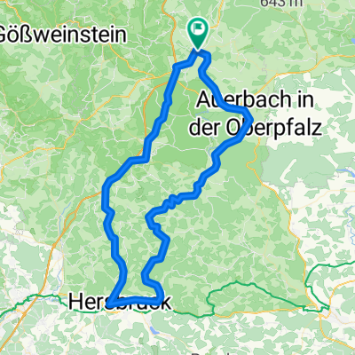
Pegnitz - Bayreuth
A cycling route starting in Pegnitz, Bavaria, Germany.
Overview
About this route
Čím více zde napíšete informací, tím více bude užitečnější pro ostatním uživatele.<br /><br />* Průběh trasy.<br />* Co je zvláštní na této trase?<br />* Proč doporučit tuto trasu?<br />* Co se Vám zde nejvíce líbilo?<br />* Atd.
- -:--
- Duration
- 90.7 km
- Distance
- 570 m
- Ascent
- 652 m
- Descent
- ---
- Avg. speed
- ---
- Max. altitude
Route quality
Waytypes & surfaces along the route
Waytypes
Quiet road
41.3 km
(46 %)
Road
13.9 km
(15 %)
Surfaces
Paved
56.7 km
(63 %)
Unpaved
13.7 km
(15 %)
Asphalt
53.8 km
(59 %)
Gravel
4.8 km
(5 %)
Route highlights
Points of interest along the route
Point of interest after 23.7 km
Skalní jehly
Point of interest after 56.2 km
Skalní zaharda
Point of interest after 89 km
Centrum - Maxmilianstr.
Point of interest after 89.2 km
Point of interest after 89.6 km
Zámek
Continue with Bikemap
Use, edit, or download this cycling route
You would like to ride Pegnitz - Bayreuth or customize it for your own trip? Here is what you can do with this Bikemap route:
Free features
- Save this route as favorite or in collections
- Copy & plan your own version of this route
- Split it into stages to create a multi-day tour
- Sync your route with Garmin or Wahoo
Premium features
Free trial for 3 days, or one-time payment. More about Bikemap Premium.
- Navigate this route on iOS & Android
- Export a GPX / KML file of this route
- Create your custom printout (try it for free)
- Download this route for offline navigation
Discover more Premium features.
Get Bikemap PremiumFrom our community
Other popular routes starting in Pegnitz
 Pegnitz - Kleiner Kulm - Pegnitz
- Distance
- 14.1 km
- Ascent
- 396 m
- Descent
- 394 m
- Location
- Pegnitz, Bavaria, Germany
 Von Pegnitz durch den Veldensteiner Forst
- Distance
- 83.7 km
- Ascent
- 624 m
- Descent
- 575 m
- Location
- Pegnitz, Bavaria, Germany
 Veldensteiner Forst Runde
- Distance
- 45.1 km
- Ascent
- 535 m
- Descent
- 535 m
- Location
- Pegnitz, Bavaria, Germany
 Veldensteiner Forst - Burg Hartenstein
- Distance
- 48.7 km
- Ascent
- 590 m
- Descent
- 587 m
- Location
- Pegnitz, Bavaria, Germany
 Bronn-Michelfeld
- Distance
- 10.7 km
- Ascent
- 162 m
- Descent
- 176 m
- Location
- Pegnitz, Bavaria, Germany
 Schiem-a-no.de: Tour1/Pegnitz-Pottenstein
- Distance
- 35.1 km
- Ascent
- 647 m
- Descent
- 647 m
- Location
- Pegnitz, Bavaria, Germany
 Pegnitz-Weiglathal-Leups-Pegnitz
- Distance
- 55.8 km
- Ascent
- 788 m
- Descent
- 786 m
- Location
- Pegnitz, Bavaria, Germany
 Pegnitz - Bayreuth
- Distance
- 90.7 km
- Ascent
- 570 m
- Descent
- 652 m
- Location
- Pegnitz, Bavaria, Germany
Open it in the app