

Hunsrück Schnupperkurs
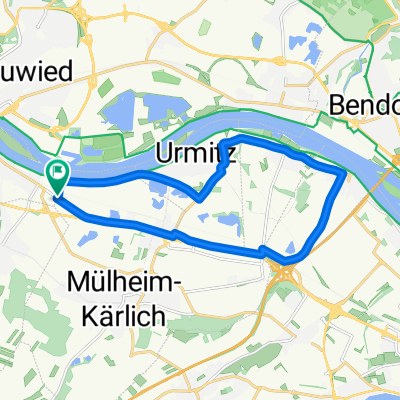
A cycling route starting in Kettig, Rhineland-Palatinate, Germany.
Overview
About this route
Beautiful round along the Rhine to Boppard, then up to Buchholz and down to the Moselle in Brodenbach. Then leisurely back along the Moselle to Kettig!
- -:--
- Duration
- 83.3 km
- Distance
- 462 m
- Ascent
- 462 m
- Descent
- ---
- Avg. speed
- ---
- Max. altitude

Route quality
Waytypes & surfaces along the route
Waytypes
Path
17.5 km
(21 %)
Quiet road
14.2 km
(17 %)
Surfaces
Paved
57.5 km
(69 %)
Unpaved
10 km
(12 %)
Asphalt
53.3 km
(64 %)
Gravel
8.3 km
(10 %)
Continue with Bikemap
Use, edit, or download this cycling route
You would like to ride Hunsrück Schnupperkurs or customize it for your own trip? Here is what you can do with this Bikemap route:
Free features
- Save this route as favorite or in collections
- Copy & plan your own version of this route
- Split it into stages to create a multi-day tour
- Sync your route with Garmin or Wahoo
Premium features
Free trial for 3 days, or one-time payment. More about Bikemap Premium.
- Navigate this route on iOS & Android
- Export a GPX / KML file of this route
- Create your custom printout (try it for free)
- Download this route for offline navigation
Discover more Premium features.
Get Bikemap PremiumFrom our community
Other popular routes starting in Kettig
 Kettig rund Laacher-See
- Distance
- 41.9 km
- Ascent
- 633 m
- Descent
- 633 m
- Location
- Kettig, Rhineland-Palatinate, Germany
 Zeitfahren
- Distance
- 15.2 km
- Ascent
- 41 m
- Descent
- 42 m
- Location
- Kettig, Rhineland-Palatinate, Germany
 Köppel 8
- Distance
- 60.3 km
- Ascent
- 584 m
- Descent
- 584 m
- Location
- Kettig, Rhineland-Palatinate, Germany
 Flugplatz Miesenheim
- Distance
- 19.7 km
- Ascent
- 146 m
- Descent
- 147 m
- Location
- Kettig, Rhineland-Palatinate, Germany
 Auf zum letzten Amerikaner
- Distance
- 80.2 km
- Ascent
- 671 m
- Descent
- 671 m
- Location
- Kettig, Rhineland-Palatinate, Germany
 Im Kleinflur 5, Kettig nach Im Kleinflur 4, Kettig
- Distance
- 19.1 km
- Ascent
- 105 m
- Descent
- 104 m
- Location
- Kettig, Rhineland-Palatinate, Germany
 Rittersturz u. Kondertal
- Distance
- 40.9 km
- Ascent
- 523 m
- Descent
- 523 m
- Location
- Kettig, Rhineland-Palatinate, Germany
 Vulkantour Pellenz-Maifeld
- Distance
- 52.3 km
- Ascent
- 390 m
- Descent
- 390 m
- Location
- Kettig, Rhineland-Palatinate, Germany
Open it in the app