

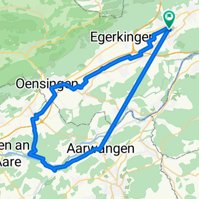
3. Etappe: Kappel - Barbareche
A cycling route starting in Hägendorf, Canton of Solothurn, Switzerland.
Overview
About this route
- -:--
- Duration
- 102.1 km
- Distance
- 548 m
- Ascent
- 349 m
- Descent
- ---
- Avg. speed
- ---
- Max. altitude

Route quality
Waytypes & surfaces along the route
Waytypes
Quiet road
19.4 km
(19 %)
Road
18.4 km
(18 %)
Surfaces
Paved
46 km
(45 %)
Unpaved
5.1 km
(5 %)
Asphalt
44.9 km
(44 %)
Gravel
3.1 km
(3 %)
Route highlights
Points of interest along the route
Point of interest after 0 km
Am Morgen früh los, endlich Mal. Außerdem ist das Wetter jetzt sehr freundlich geworden.
Point of interest after 30.2 km
Solothurn, sehr nettes Städtchen mit rausgeputzter Altstadt.
Point of interest after 57.4 km
Oh oh, es scheint das ich die geheime Ecke der Schweiz entdeckt hab. Industrie, laut, dreckig und es geht ins Flachland.
Point of interest after 93.5 km
Falsch gefahren, Mist. Ist erst aufgefallen, als Nino und Sabine mir entgegenkamen und fragten wo es nach Fribourg geht. Ähm, ja da wollte ich auch hin, tja dann mal wieder umkehren.
Point of interest after 102.1 km
Ab in den Wald. Nino und Sabine sind weiter nach Fribourg und ich hab gemerkt, dass das Aufnahmegerät nicht an war...mist, kein O-Ton.
Continue with Bikemap
Use, edit, or download this cycling route
You would like to ride 3. Etappe: Kappel - Barbareche or customize it for your own trip? Here is what you can do with this Bikemap route:
Free features
- Save this route as favorite or in collections
- Copy & plan your own version of this route
- Split it into stages to create a multi-day tour
- Sync your route with Garmin or Wahoo
Premium features
Free trial for 3 days, or one-time payment. More about Bikemap Premium.
- Navigate this route on iOS & Android
- Export a GPX / KML file of this route
- Create your custom printout (try it for free)
- Download this route for offline navigation
Discover more Premium features.
Get Bikemap PremiumFrom our community
Other popular routes starting in Hägendorf
 Hägendorf Staffelegg Scherz Hägendorf
- Distance
- 91 km
- Ascent
- 864 m
- Descent
- 864 m
- Location
- Hägendorf, Canton of Solothurn, Switzerland
 oberer Hauenstein Baselbiet Benkerjoch
- Distance
- 104.5 km
- Ascent
- 1,376 m
- Descent
- 1,376 m
- Location
- Hägendorf, Canton of Solothurn, Switzerland
 Hägendorf-Solothurn
- Distance
- 41.1 km
- Ascent
- 257 m
- Descent
- 251 m
- Location
- Hägendorf, Canton of Solothurn, Switzerland
 Moderate Route in Hägendorf
- Distance
- 39.7 km
- Ascent
- 133 m
- Descent
- 134 m
- Location
- Hägendorf, Canton of Solothurn, Switzerland
 BaselbietOst mit Passwang
- Distance
- 99.2 km
- Ascent
- 1,808 m
- Descent
- 1,808 m
- Location
- Hägendorf, Canton of Solothurn, Switzerland
 Langenbruckstrasse 17, Hägendorf nach Langenbruckstrasse 10, Hägendorf
- Distance
- 24.7 km
- Ascent
- 589 m
- Descent
- 585 m
- Location
- Hägendorf, Canton of Solothurn, Switzerland
 Letzte Etappe Bodensee Rundfahrt
- Distance
- 45.6 km
- Ascent
- 185 m
- Descent
- 110 m
- Location
- Hägendorf, Canton of Solothurn, Switzerland
 Test Route E-Bike
- Distance
- 50.3 km
- Ascent
- 930 m
- Descent
- 875 m
- Location
- Hägendorf, Canton of Solothurn, Switzerland
Open it in the app