

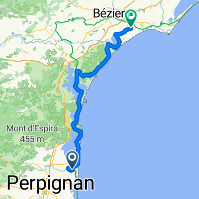
Banyuls - Sète
A cycling route starting in Torreilles, Occitanie, France.
Overview
About this route
- -:--
- Duration
- 144.7 km
- Distance
- 269 m
- Ascent
- 255 m
- Descent
- ---
- Avg. speed
- ---
- Max. altitude
Continue with Bikemap
Use, edit, or download this cycling route
You would like to ride Banyuls - Sète or customize it for your own trip? Here is what you can do with this Bikemap route:
Free features
- Save this route as favorite or in collections
- Copy & plan your own version of this route
- Split it into stages to create a multi-day tour
- Sync your route with Garmin or Wahoo
Premium features
Free trial for 3 days, or one-time payment. More about Bikemap Premium.
- Navigate this route on iOS & Android
- Export a GPX / KML file of this route
- Create your custom printout (try it for free)
- Download this route for offline navigation
Discover more Premium features.
Get Bikemap PremiumFrom our community
Other popular routes starting in Torreilles
 Torreilles - Portiragnes
- Distance
- 102.2 km
- Ascent
- 269 m
- Descent
- 266 m
- Location
- Torreilles, Occitanie, France
 De D81, Torreilles à Place du Maréchal Joffre, Torreilles
- Distance
- 2.7 km
- Ascent
- 0 m
- Descent
- 0 m
- Location
- Torreilles, Occitanie, France
 volta vtt Torreilles
- Distance
- 18.1 km
- Ascent
- 19 m
- Descent
- 16 m
- Location
- Torreilles, Occitanie, France
 Torreilles a BARCARES
- Distance
- 30.1 km
- Ascent
- 13 m
- Descent
- 12 m
- Location
- Torreilles, Occitanie, France
 ETAPPE 12 - Sainte-Marie-la-Mer nach La Bola
- Distance
- 119.2 km
- Ascent
- 770 m
- Descent
- 765 m
- Location
- Torreilles, Occitanie, France
 De Boulevard des Plages, Torreilles à D627, Leucate
- Distance
- 16.9 km
- Ascent
- 0 m
- Descent
- 3 m
- Location
- Torreilles, Occitanie, France
 Torreilles - Maureillas-las-Illas
- Distance
- 57.5 km
- Ascent
- 241 m
- Descent
- 96 m
- Location
- Torreilles, Occitanie, France
 Torreilles - Cervera de la Marenda
- Distance
- 61.9 km
- Ascent
- 1,268 m
- Descent
- 1,246 m
- Location
- Torreilles, Occitanie, France
Open it in the app