

Schladming Bergstation Planei ins Tal
A cycling route starting in Schladming, Styria, Austria.
Overview
About this route
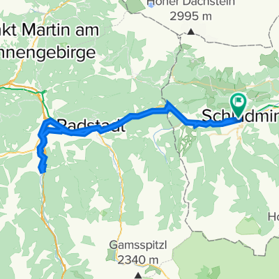
Nach der gemütlichen Auffahrt mit der Planai-Gondelbahn bietet diese Runde 2 Startmöglichkeiten: Bei Variante 1 beginnt man von der Planai-Bergstation und fährt entlang der blauen Beschilderung auf der Family-Downhillstrecke von der Bergstation bis zur Mittelstation. Die Strecke wurde so angelegt, dass die steilen Passagen umfahren werden und somit für Familien und Kinder besonders geeignet ist. Fortführung der Runde ist über Variante 2, welche gleich bei der Mittelstation beginnt. Diese führt entlang der asphaltierten Planaistraße bis zur Abzweigung Fastenberg Richtung Untertal. Von dort geht es weiterhin gemütlich bergab bis zur Janerbrücke, wo man rechts abbiegt. Nach weiteren 2 km biegt man bei der Straßengabelung links ab Richtung Obertal bis zum „Windbacher“, wo man auf der gegenüberliegenden Bergseite, mit einem Blick auf das herrliche Panorama, Richtung Rohrmoos- Süd fährt. Vorbei an der Talstation des „Sun-Jet“ gelangt man auf die Rohrmooser Straße, wo ein ca. 2 km langer Anstieg bis zur Abzweigung Richtung Preunegg erfolgt. Ebenfalls auf der gegenüberliegenden Bergseite fährt man von Preunegg Richtung Pichl, von wo man entlang des R7 nach Schladming gelangt.
- -:--
- Duration
- 36.8 km
- Distance
- 419 m
- Ascent
- 1,501 m
- Descent
- ---
- Avg. speed
- ---
- Max. altitude
Continue with Bikemap
Use, edit, or download this cycling route
You would like to ride Schladming Bergstation Planei ins Tal or customize it for your own trip? Here is what you can do with this Bikemap route:
Free features
- Save this route as favorite or in collections
- Copy & plan your own version of this route
- Sync your route with Garmin or Wahoo
Premium features
Free trial for 3 days, or one-time payment. More about Bikemap Premium.
- Navigate this route on iOS & Android
- Export a GPX / KML file of this route
- Create your custom printout (try it for free)
- Download this route for offline navigation
Discover more Premium features.
Get Bikemap PremiumFrom our community
Other popular routes starting in Schladming
 Einrollen Ramsau 21.07.2014
- Distance
- 26.7 km
- Ascent
- 432 m
- Descent
- 432 m
- Location
- Schladming, Styria, Austria
 Top 6 Schladming 08 medium
- Distance
- 47.4 km
- Ascent
- 1,654 m
- Descent
- 1,661 m
- Location
- Schladming, Styria, Austria
 Ennstalrunde
- Distance
- 67.7 km
- Ascent
- 608 m
- Descent
- 609 m
- Location
- Schladming, Styria, Austria
 Schladming Flachau Rundweg
- Distance
- 61.3 km
- Ascent
- 224 m
- Descent
- 223 m
- Location
- Schladming, Styria, Austria
 Schladming Bergstation Planei ins Tal
- Distance
- 36.8 km
- Ascent
- 419 m
- Descent
- 1,501 m
- Location
- Schladming, Styria, Austria
 Sonnseitn Tour
- Distance
- 26.4 km
- Ascent
- 518 m
- Descent
- 518 m
- Location
- Schladming, Styria, Austria
 MTB Runde. Ramsau - Hochwurzen - Fastenberg - Pichl - Ramsau
- Distance
- 53.3 km
- Ascent
- 1,912 m
- Descent
- 1,912 m
- Location
- Schladming, Styria, Austria
 Planai
- Distance
- 17.9 km
- Ascent
- 1,105 m
- Descent
- 96 m
- Location
- Schladming, Styria, Austria
Open it in the app