

2012 French Tour -- Ride Day 39 -- 27 September 2012 -- Sisteron to Champtercier (via Dignes-les-Bains)
A cycling route starting in Sisteron, Provence-Alpes-Côte d'Azur Region, France.
Overview
About this route
To be added later...
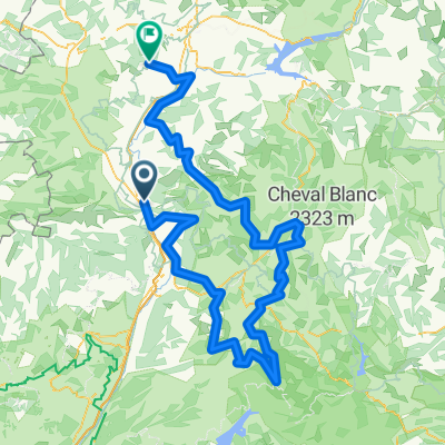
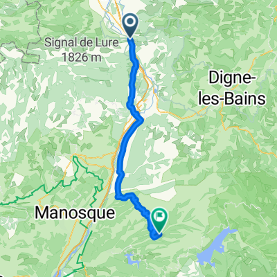
D3 and D17 were superb roads with almost no traffic and incredible scenery and vistas. Much of the route is called the Route du Temps due to the geological features and there is some explanations of these features along the way. We even saw what we assume was a high school group out studying the rocks.
N85 had too much traffic and was no pleasure. D2085 was better and had some bike lanes approaching Digne.
Along D3, we passed through several Cols. I'll have to add details later. <div><br /></div>
- -:--
- Duration
- 74.4 km
- Distance
- 1,107 m
- Ascent
- 977 m
- Descent
- ---
- Avg. speed
- ---
- Max. altitude

Route quality
Waytypes & surfaces along the route
Waytypes
Road
61 km
(82 %)
Quiet road
2.2 km
(3 %)
Surfaces
Paved
59.5 km
(80 %)
Asphalt
59.5 km
(80 %)
Undefined
14.9 km
(20 %)
Continue with Bikemap
Use, edit, or download this cycling route
You would like to ride 2012 French Tour -- Ride Day 39 -- 27 September 2012 -- Sisteron to Champtercier (via Dignes-les-Bains) or customize it for your own trip? Here is what you can do with this Bikemap route:
Free features
- Save this route as favorite or in collections
- Copy & plan your own version of this route
- Sync your route with Garmin or Wahoo
Premium features
Free trial for 3 days, or one-time payment. More about Bikemap Premium.
- Navigate this route on iOS & Android
- Export a GPX / KML file of this route
- Create your custom printout (try it for free)
- Download this route for offline navigation
Discover more Premium features.
Get Bikemap PremiumFrom our community
Other popular routes starting in Sisteron
 Le Desert met campings (deel 1)
- Distance
- 275.9 km
- Ascent
- 8,962 m
- Descent
- 8,158 m
- Location
- Sisteron, Provence-Alpes-Côte d'Azur Region, France
 Durance - Buech - Eygues
- Distance
- 306.8 km
- Ascent
- 1,098 m
- Descent
- 1,111 m
- Location
- Sisteron, Provence-Alpes-Côte d'Azur Region, France
 Sorti du 1/09/2021 a Sisteron
- Distance
- 7.7 km
- Ascent
- 49 m
- Descent
- 60 m
- Location
- Sisteron, Provence-Alpes-Côte d'Azur Region, France
 From Sisteron to Allemagne-en-Provence
- Distance
- 67.8 km
- Ascent
- 1,072 m
- Descent
- 1,133 m
- Location
- Sisteron, Provence-Alpes-Côte d'Azur Region, France
 Sisteron - Circle to Peipin
- Distance
- 14.8 km
- Ascent
- 145 m
- Descent
- 138 m
- Location
- Sisteron, Provence-Alpes-Côte d'Azur Region, France
 4. Tag Sisteron - Moustiers
- Distance
- 88.8 km
- Ascent
- 722 m
- Descent
- 613 m
- Location
- Sisteron, Provence-Alpes-Côte d'Azur Region, France
 2012 French Tour -- Ride Day 39 -- 27 September 2012 -- Sisteron to Champtercier (via Dignes-les-Bains)
- Distance
- 74.4 km
- Ascent
- 1,107 m
- Descent
- 977 m
- Location
- Sisteron, Provence-Alpes-Côte d'Azur Region, France
 Sisteron - Circle to Clamensane and beyond
- Distance
- 58.8 km
- Ascent
- 662 m
- Descent
- 662 m
- Location
- Sisteron, Provence-Alpes-Côte d'Azur Region, France
Open it in the app