

Veľká kľakovská aréna
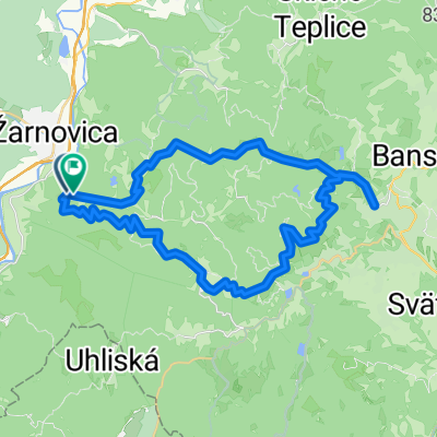
A cycling route starting in Žarnovica, Banská Bystrica Region, Slovakia.
Overview
About this route
A very demanding route. There are sections where you have to push the bike, for example (the crossing to the Ždaňská/Prochoťská side about 400 m, then from Gronštol above Kanie studne it's tough, the middle third - at Kních studniach the bike is pushed (1 km). The last 150 m to Vtáčnik the bike must be carried on the back. On the descent from Vtáčnik there are only small carries up to 100 m – near Klášťorská skala and Kamenné vráta.
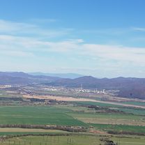
The views from Vtáčnik and the places along the route are unforgettable. The descent along the ridge from Vtáčnik following the red trail down to Tatra is perfect. The route only needs to be ridden once, and the second time it's better to choose shorter and more interesting variants, especially for the end of the ride. From Rúbaný vrch to Veľké Pole, the brake discs take a beating, riding through forest without views, on gravel roads.
Convenient escapes from the ridge are at Rúbaný vrch (in both directions), at Tatra towards Ostrý Grúň, and at Sucha hora towards Horná Ves. Between Tatra and Sucha hora there is a road towards Píla, but it is not very comfortable (see route Župkov - Vtáčnik - Píla - Župkov).
- -:--
- Duration
- 53.3 km
- Distance
- 1,327 m
- Ascent
- 1,328 m
- Descent
- ---
- Avg. speed
- ---
- Max. altitude
Route highlights
Points of interest along the route

Point of interest after 7.6 km
Čierťaže

Point of interest after 11.4 km
Krmelec

Point of interest after 13.5 km
Koniec lesnej asfaltovej cesty

Point of interest after 13.8 km
cca 250 m od konca asfaltovej cesty odbočiť doprava, zo začiatku po lesnej ceste, ktorá sa postupne vytratí. Pokračovať cez les bez cesty, cez sedielko, celkovo cca 450m na modrú značku

Point of interest after 23.4 km
Gronštolne (909 m.n.m.)

Point of interest after 23.4 km
Granštolne - príjemné miesto na oddych pred zaberačkou na Kanie studne

Point of interest after 26.3 km
Kanie studne, pohľad na sever

Point of interest after 28 km
Posledné metre na Vtáčnik sa biky nesú na chrbte

Point of interest after 28.2 km
Vtáčnik, krásny výhľad na Pohronie aj Hornú Nitru

Point of interest after 29.4 km
Kláštorská skala

Point of interest after 32.6 km
Rúbaný vrch, pohľad na východ

Point of interest after 32.6 km
Križovanie žltej značky

Point of interest after 34.8 km
Obice, horná lúka

Point of interest after 36.8 km
Nie je veľa únikových ciest z hrebeňa, táto evidentne nie je pre bikerov najvhodnejšia
Continue with Bikemap
Use, edit, or download this cycling route
You would like to ride Veľká kľakovská aréna or customize it for your own trip? Here is what you can do with this Bikemap route:
Free features
- Save this route as favorite or in collections
- Copy & plan your own version of this route
- Sync your route with Garmin or Wahoo
Premium features
Free trial for 3 days, or one-time payment. More about Bikemap Premium.
- Navigate this route on iOS & Android
- Export a GPX / KML file of this route
- Create your custom printout (try it for free)
- Download this route for offline navigation
Discover more Premium features.
Get Bikemap PremiumFrom our community
Other popular routes starting in Žarnovica
 Dolne-Hamre-Banska-Stiavnica-Okruh
- Distance
- 43.6 km
- Ascent
- 2,340 m
- Descent
- 2,339 m
- Location
- Žarnovica, Banská Bystrica Region, Slovakia
 Voznica_Kopanice-horou
- Distance
- 24.7 km
- Ascent
- 737 m
- Descent
- 724 m
- Location
- Žarnovica, Banská Bystrica Region, Slovakia
 Žarnovica 18419
- Distance
- 9.8 km
- Ascent
- 413 m
- Descent
- 177 m
- Location
- Žarnovica, Banská Bystrica Region, Slovakia
 sobota robota 23.3.19
- Distance
- 16 km
- Ascent
- 166 m
- Descent
- 202 m
- Location
- Žarnovica, Banská Bystrica Region, Slovakia
 Vyhne-Bzenica-Skl.Teplice-Ban.Stiavnica-Vyhne
- Distance
- 38.8 km
- Ascent
- 665 m
- Descent
- 665 m
- Location
- Žarnovica, Banská Bystrica Region, Slovakia
 Dolná Ždaňa do Doktor Janského 7
- Distance
- 32.5 km
- Ascent
- 590 m
- Descent
- 551 m
- Location
- Žarnovica, Banská Bystrica Region, Slovakia
 Cesta 512, Horné Hámre až Banícka, Nová Baňa
- Distance
- 40.8 km
- Ascent
- 189 m
- Descent
- 233 m
- Location
- Žarnovica, Banská Bystrica Region, Slovakia
 Vtacnik-Hrabicov
- Distance
- 31.3 km
- Ascent
- 1,397 m
- Descent
- 1,406 m
- Location
- Žarnovica, Banská Bystrica Region, Slovakia
Open it in the app